Disclosure : This site contains affiliate links to products. We may receive a commission for purchases made through these links.
Poland: CartoMedia Walking Maps of Southern Polish Highlands
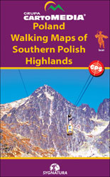
Detailed contoured and GPS compatible hiking maps from the CartoMedia group covering the highlands of southern Poland, including coverage of the Slovak side of the Tatra Mountains. The maps highlight numerous walking trails, showing approx. hiking times in both directions, the degree of difficulty and possible danger points. Symbols indicate mountain huts, campsites and other tourist accommodation, various places of interest, etc. Most titles also include cross-country and alpine ski trails and mountain bike routes. Road network shows petrol stations and bus stops. The maps also show railways with stations and all types of mountain transport: cable cars, chair list, ski lifts, etc. All the maps have latitude and longitude lines, usually at 1โ€ intervals, and multilingual map legend which includes English. Several titles also have street plans of local resorts.

Related Products:
 Poland: ExpressMap Hiking Maps
 Western Tatras – Polish and Slovak
 High Tatras – Polish and Slovak
 Poland: Compass Hiking Maps
 Switzerland: Kรผmmerly + Frey 60K Walking Maps
 Spain: Editorial Alpina Walking Maps
 Argentina: de Dios Tourist Maps of Popular Regions
 Italy: Tabacco 25K Walking Maps of the Dolomites and North-Eastern Italy
 Western Tatra Mountains Polish and Slovak ExpressMap Tourist Map
 Spain: Reise Know-How Walking and Touring Maps of Mallorca
 Hungary: Cartographia Hiking Maps
 High and Bielskie Tatra Mountains – Polish and Slovak ExpressMap Tourist Map
 Italy: F&B Walking Maps of the Dolomites
 Italy: IGA 25K Hiking Maps of Central Italy
 Italy: IGA 50K Hiking Maps of Central Italy
 Austria: Freytag & Berndt Cycling Maps
 Italy: Ed. Multigraphic Walking Maps of Central Italy
 Ibiza – Formentera Editorial Alpina
 Poland: Michelin Regional Road Maps
 New Zealand: Kiwimaps District Road Maps with Street Plans
 Bulgaria: Domino Hiking Maps
 Beskid Maly
 Beskid Zywiecki
 Latvia: Jana Seta 75K Maps of Environs of Main Towns
 Slovenia: Kompass 75K Hiking and Cycling Maps
 Italy: Fraternali Editore Hiking Maps of Southern Italian Alps
 Italy: Kรผmmerly + Frey Outdoor Maps of Northern Italy
 Switzerland: Hallwag 50K Outdoor Maps
 Italy: Kompass 25K/40K Hiking Maps of the Dolomites
Mazury Lake District – Southern Part ExpressMap Tourist Map
Italy: Kompass 25K/40K Hiking Maps of the Dolomites
Mazury Lake District – Southern Part ExpressMap Tourist Map
 Greece: Terrain Editions Maps for Hiking and Recreational Pursuits
 Poland ExpressMap Professional Users Road Atlas 2020/2021
 Italy: IGC 50K Walking Maps of North-Western Italy
 Serbia/Montenegro: Geokarta Hiking and Recreational Maps
France: Rando Editions/IGN 50K Walking Maps of the Pyrenees
Serbia/Montenegro: Geokarta Hiking and Recreational Maps
France: Rando Editions/IGN 50K Walking Maps of the Pyrenees
 Great Britain: CroydeCycle Local Walking Maps of the West Country
 Austria: Freytag & Berndt 150K “Top 10 Tips” Road Maps
 La Palma F&B WKE2
 Slovenia: Kartografija 75K Hiking Maps
 Walking the Munros Vol 1 – Southern, Central and Western Highlands