Disclosure : This site contains affiliate links to products. We may receive a commission for purchases made through these links.
Pirin (BG) – Orvilos – Vrontou (GR) Geopsis 134
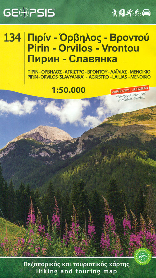
Pirin Mountais in south-western Bulgaria, plus Orvilos and Vrondous (Vrontou) Mountains in northern Greece on a light, waterproof and tear-resistant, contoured and GPS compatible amt at 1:50,000 from Greek publishers Geopsis, highlighting waymarked hiking trails, places of interest, etc.On one side are the Pirin Mountain in Bulgaria with coverage extending from Razlog and Bansko in the north to Melnik and Pirin in the south, i.e. short of the Bulgarian/Greek border. An overprint highlights waymarked hiking trails, indicating distances. Possible danger points are clearly marked, both on the waymarked and on other local paths. Symbols indicate various facilities including tourist accommodation, mountain huts, restaurants, climbing areas, etc. Finely graded road network indicates locations of petrol stations and car parks. The map has lists of mountain shelters and of hiking routes from various locations.On the reverse, without the overlap with the Pirin map, is coverage of the Orvilos Mountains straddling the Bulgarian/Greek border, plus Vrondous (Vrontou), Menoikkio and Agkistro Mountains north of Serres in the Greek region of Macedonia. The map shows local paths, graded according to their condition, plus four waymarked routes. Symbols also indicate various local facilities (mountain huts, taverns, etc). Road network shows distances on many small local roads, petrol stations, etc. Both sided have vivid presentation of topography (contours at 20m intervals with spot heights and bold relief shading) and a 1km UTM grid with margin ticks and crosshairs at 1’ intervals. Place names are, as appropriate, in both Greek/Cyrillic and Latin alphabest. The two map legends include English.

Related Products:
 Eastern Rhodopes / Rodopi Geopsis 131
 Central Rhodopes / Rodopi Geopsis 132
 Western Rhodopes / Rodopi – Falakro Geopsis 133
 Bansko (with Pirin National Park)
 Pirin Mountains Domino
 Rila – Pirin terraQuest Trekking Map
 Thasos Geopsis 214
 Lesbos Geopsis 211
 Tatra Mountains PL/SK
 Kos Geopsis 212
 Western Tatras – Polish and Slovak
 Olympus Geopsis 139
 Western Rhodope Mountains Domino Map
 Prato Province Hiking Routes
 Lesbos: Aghiasos & Environs 18K Geopsis Map
 Transrhodopi – Long distance hiking and biking trail From Trigrad to Ivaylovgrad
 Alsace – Vosges North – Hagenau – Starsburg 2-Map Set Kompass 2220
 Lesbos: Mitilini Peninsula 18K Geopsis Map
 Lesbos: Kalloni Area 33K Geopsis Map
 Omiลกka Dinara
 Rodnei Mountains Dimap Hiking Map
 Strandzha Mountains: Burgas to the Turkish Border Domino Map
 Greece: Geopsis Hiking Maps of North-Eastern Greece
 Eastern Rhodope Mountains
 Dinara – Troglav Group West
 Mt Paggaio
 Drakensberg Range 5 – Cobham – Lotheni – Vrgelegen – Cobham
 Pica d`Estats – Mont-roig Editorial Alpina
 Biokovo Mountains Croatian Mountain Rescue Service 25K Map
 Pica d`Estats – Mont-roig – Vall Ferrera – Valls de Cardos Editorial Alpina
 Istria: Cicarija Plateau Croatian Mountain Rescue Service 25K Map
 Polish and Slovak Tatra Mountains
 White Mountains / Lefka Ori – Sfakia – Pahnes Anavasi 11.11/11.12
 Kamnik and Savinja Alps Kartografija WATERPROOF Hiking Map
 Smolyan – Chepelare – Pamorovo and the Surrounding Area
 Stara Planina Western: Berkovita to Zlatitsa Domino Map
 Dinara
 Stara Planina Central: Uzana to Vratnik Domino Map