Disclosure : This site contains affiliate links to products. We may receive a commission for purchases made through these links.
Philadelphia & Mid-Atlantic States ITMB

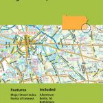
Philadelphia and the Mid-Atlantic States of USA on a waterproof and tear-resistant map from ITMB, offering on one side a clear street plan of central Philadelphia and on the reverse an indexed road map extending from Boston to Jacksonville in North Carolina and inland to Niagara Falls and Pittsburgh.On one side is an indexed street plan of central Philadelphia, covering the districts from the Delaware River to the western side of the Schuylkill River. Metro and Patco station are clearly marked and named; for motorists main traffic arteries are highlighted and one way streets and car parks are marked. Symbols indicate various places of interest and facilities, including selected hotels and restaurants, museums, etc. On the reverse is an indexed road map presenting the Mid-Atlantic states at 1:1,000,000. Topography is indicated by altitude colouring with spot heights in feet; national parks and other protected areas are highlighted. Road network distinguishes between free and toll interstate highways and clearly shows road numbers. Driving distances are marked on interstate and selected state roads. Railway lines are included and local airports are marked. Symbols indicate various places of interest. The map is indexed and has latitude and longitude lines at 1ยฐ intervals.

Related Products:
 USA South: Atlantic States ITMB
 Baltic States ITMB
 Philadelphia Borch
 Mexico Border States: Coahuila, Nuevo Leon, Tamaulipas ITMB
 Great Lakes ITMB
 Hungary & Budapest ITMB
 USA Southwest ITMB
 Montreal & Southern Quebec ITMB
 Bhutan & Northeast India ITMB
 Central USA & the Mississippi River ITMB
 USA Western Railroads/Highways ITMB
 Quito & Central Ecuador ITMB
 Jerusalem & Holy Land ITMB
 Malawi & Mozambique ITMB
 Rome & Southern Italy ITMB
 Pakistan ITMB
 Belarus ITMB
 Tel Aviv-Jaffa & Central Israel ITMB
 Philadelphia & Pennsylvania ITMB
 Bangkok & Thailand South ITMB
 Senegal & Gambia ITMB
 Easter Island & Santiago ITMB
 Texas & Oklahoma ITMB
 Cayman Islands & Jamaica ITMB
 Jordan & Syria ITMB
 Philadelphia & Southeast Pennsylvania Regional Rand McNally
 Bolivia ITMB
 Santiago & Chile North ITMB
 Iran & Tehran ITMB
 Seattle & Northwest USA ITMB
 Albania ITMB
 California ITMB
 Argentina South & Tierra del Fuego ITMB
 Mauritius & Reunion ITMB
 Netherlands & Belgium ITMB
 Delhi & Northern India ITMB
 Philadelphia PA Rand McNally
 Ghana ITMB
 Georgia & Armenia ITMB