Disclosure : This site contains affiliate links to products. We may receive a commission for purchases made through these links.
Peru ITMB
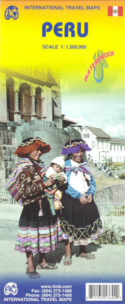
Peru at 1:1,500,000 on a double-sided, waterproof and tear-resistant, indexed map from ITMB, with large, clear street plans of central Lima and Cusco, highlighting accommodation, places of interest and various facilities.The map divides the country north/south, approximately along the line between the Cordillera Blanca and Cordillera Huyahuash, with very little overlap between the two sides. Topography is very effectively presented by altitude colouring, with spot heights and additional graphics for swamps and marshland, glaciers and volcanos.The map shows the country’s road network distinguishing between all-weather and seasonable roads and indicates driving distances on main routes. Railway lines, including the popular routes linking Cusco with Puno and Arequipa, are very clearly shown. The map also shows local airports and airstrips, as well as internal administrative boundaries with names of the provinces.National parks are highlighted and symbols indicate various other places of interest, including the country archaeological sites. Latitude and longitude lines are drawn at intervals of 1ยฐ. Each side has a separate index of localities.Also included are very clear street plans of central Lima and Cusco highlighting selected accommodation, supermarkets, various institutions and places of interest, etc.

Related Products:
 Cusco & Peru South ITMB
 Lima & Central Peru ITMB
 Peru – Ecuador Nelles
 Peru Mapa Vial
 Afghanistan ITMB
 Bolivia ITMB
 South America – The Andes Nelles
 Algeria ITMB
 Cuba ITMB
 Bangladesh & India East ITMB
 Middle East ITMB Travel Atlas
 Sri Lanka & India South ITMB
Oman & Yemen ITMB
Sri Lanka & India South ITMB
Oman & Yemen ITMB
 Albania ITMB
 Romania & Moldova ITMB
 Colombia ITMB
 Australia ITMB
 Namibia ITMB
 Peru Borch
 Peru de Dios Map-Guide
 Chile ITMB
 Mexico ITMB
 Paraguay – Bolivia South ITMB
 Morocco ITMB
 Thailand, Vietnam, Laos & Cambodia ITMB Travel Atlas
 Thailand ITMB
 Russia ITMB
 Bulgaria Cartographia Road Map
 Guyana, Suriname & French Guiana ITMB
 Taiwan & Taipei ITMB
 Mongolia ITMB
 Belarus ITMB
 Myanmar / Burma ITMB
 Japan North & Hokkaido ITMB
 Argentina North & Uruguay ITMB
 Bolivia – Paraguay Nelles
 Kyoto & Japan West ITMB
 Ghana ITMB