Disclosure : This site contains affiliate links to products. We may receive a commission for purchases made through these links.
Pendleton North 1915
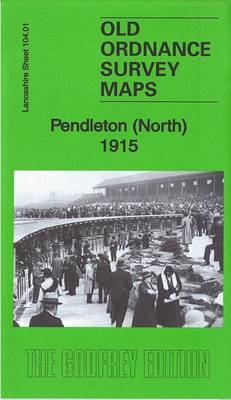
Pendleton North in 1915 in a fascinating series of reproductions of old Ordnance Survey plans in the Alan Godfrey Editions, ideal for anyone interested in the history of their neighbourhood or family. Three versions have been published for this area, showing how it developed across the years. The maps cover the northern part of Pendleton, north of Salford, from Doveleys Road and Gerald Road northward to Kersal Cell, and include Charlestown, Lower Kersal and part of Irlams o`th`Height. Features include Pendleton Colliery, Agecroft Hall Paper Works, Agecroft engine depot and railways; Kersal Cell, St George`s church, Douglas Green, Manchester Racecourse, River Irwell, Pendleton Old Hall, Agecroft Colliery, Higginson`s Brow, Agecroft Print Works, Summerville, Bridge Mill, Bridgewater Works, Manchester Bolton & Bury Canal, Willow Bank Mill, Globe Mill, Irwell Bleach Works, Selections of street directory entries are on the reverse.About the Alan Godfrey Editions of the 25″ OS Series:Selected towns in Great Britain and Ireland are covered by maps showing the extent of urban development in the last decades of the 19th and early 20th century. The plans have been taken from the Ordnance Survey mapping and reprinted at about 15 inches to one mile (1:4,340). On the reverse most maps have historical notes and many also include extracts from contemporary directories. Most maps cover about one mile (1.6kms) north/south, one and a half miles (2.4kms) across; adjoining sheets can be combined to provide wider coverage.FOR MORE INFORMATION AND A COMPLETE LIST OF ALL AVAILABLE TITLES PLEASE CLICK ON THE SERIES LINK.

Related Products:
 Manchester North West and Central Salford 1915
 Cheetham & Higher Broughton 1915 – 104.02b
Motherwell (North) 1939 – 12.09
Newton Heath 1915
Stanley 1915
Cheetham & Higher Broughton 1915 – 104.02b
Motherwell (North) 1939 – 12.09
Newton Heath 1915
Stanley 1915
 Brynmawr 1915 – 47.07
North Chorley 1909 – 77.08
Barnsley North East 1904
Burnley 1910
Brynmawr 1915 – 47.07
North Chorley 1909 – 77.08
Barnsley North East 1904
Burnley 1910
 Highams Park and Hale End 1915 – 78.01
Manchester South-East 1915
Highams Park and Hale End 1915 – 78.01
Manchester South-East 1915
 West Bromwich (North) 1885 – 68.06a Coloured Edition
Hurst and North Ashton 1906
West Bromwich (North) 1885 – 68.06a Coloured Edition
Hurst and North Ashton 1906
 Bolton North 1908
Horwich North 1907
Bolton North 1908
Horwich North 1907
 Bury North 1908
Accrington 1909
Lostock Hall and Farington North 1909
Willenhall North East 1885
East Ham & Barking 1915 – 44.3
Bury North 1908
Accrington 1909
Lostock Hall and Farington North 1909
Willenhall North East 1885
East Ham & Barking 1915 – 44.3
 Manchester: Ancoats North 1848
Wanstead 1915 – 24.3
Manchester: Ancoats North 1848
Wanstead 1915 – 24.3
 Old Trafford 1915
Worcester North-West 1902
Openshaw 1905
Old Trafford 1915
Worcester North-West 1902
Openshaw 1905
 Openshaw 1916
Barton upon Irwell 1888
Pendleton (North) 1931 – 104.01c
Stourbridge (North) & Amblecote 1901 – 4.10a
Openshaw 1916
Barton upon Irwell 1888
Pendleton (North) 1931 – 104.01c
Stourbridge (North) & Amblecote 1901 – 4.10a
 Chadderton North 1932
North Shields and Chirton 1894
Shut End and Tansey Green 1903
Sandwell Hall 1902
Stockton (North) 1899 – 50.12a
Wakefield (North) 1890 – 248.03a
Sheffield (North) 1903 – 294.04b
Farington South and Leyland North 1909
Chadderton North 1932
North Shields and Chirton 1894
Shut End and Tansey Green 1903
Sandwell Hall 1902
Stockton (North) 1899 – 50.12a
Wakefield (North) 1890 – 248.03a
Sheffield (North) 1903 – 294.04b
Farington South and Leyland North 1909
 Tottington 1908
 Leytonstone & Leyton 1915 – 23.3
Pelton Fell 1915
Leytonstone & Leyton 1915 – 23.3
Pelton Fell 1915