Disclosure : This site contains affiliate links to products. We may receive a commission for purchases made through these links.
Peddars Way and Norfolk Coast Path National Trail
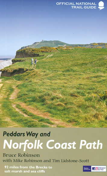
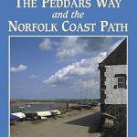
The Peddars Way and Norfolk Coast Path, a 150-km/92 mile route across Norfolk and around its northern coast between Hunstanton and Cromer, in a series of walking guides to the National Trails in England and Wales with colour extracts from the Ordnance Survey`s Explorer series at 1:25,000 showing points along the route cross-referenced to the text. The maps also indicate nearby places of interest and various facilities including campsites and caravan parks, youth hostels, water points, pubs, information or visitor centres, etc. Also shown are alternative sections of the route and stretches designated as bridleways or suitable for cycling.The guides are illustrated throughout with colour photos and include an introductory section on the path and the surrounding landscape, plus a chapter of useful information including access to various locations along the route by public transport, a list of tourist information offices and principal overnight stopping places, a bibliography, etc. Current edition of this title was published in August 2015.To see other titles in the Aurum Press series of guides to the national trails and other long-distance footpaths, please click on the series link.

Related Products:
 The Peddars Way and Norfolk Coast path: 130 mile national trail – Norfolk`s best inland and coastal scenery
 Peddars Way & Norfolk Coast Path Harvey National Trail XT40
 Norfolk Coast Path & Peddars Way
 South West Coast Path National Trail: Padstow to Falmouth
 Norfolk Coast Path and Peddars Way A-Z Adventure Atlas
 Offa`s Dyke Path National Trail
 The Peddars Way & Norfolk Coast Path – Pub Walks
 Northumberland Coast Path & Berwickshire Coastal Path Harvey National Trail XT40
 Pennine Way National Trail
 Pembrokeshire Coast Path Harvey National Trail XT40
 North Downs Way: National Trail Guide
 South West Coast Path 3 – Plymouth to Poole Harbour Harvey National Trail XT40
 South West Coast Path 2 – St Ives to Plymouth Harvey National Trail XT40
 South West Coast Path 1 – Minehead to St Ives Harvey National Trail XT40
 Exmoor & North Devon Coast Path – Minehead to Bude (South West Coast Path Part 1)
 Dorset and South Devon Coast Path – Plymouth to Poole (South West Coast Path Part 3)
 Walking the South West Coast Path: National Trail From Minehead to South Haven Point
 Great Britain: National Trails and Other Long Distance Paths
 Cornwall Coast Path – Bude to Plymouth (South West Coast Path Part 2)
 Anglesey Coastal Path Harvey National Trail XT40
 Coast to Coast West – St Bees to Keld Harvey National Trail XT40
 Exmoor & North Devon Coast Path, South-West-Coast Path Part 1: Minehead to Bude (Trailblazer British Walking Guide): Practical walking guide with 55 large-scale walking maps (1:20,000) and guides to 30 towns and villages – planning, places to stay, places
 Wales Coast Path Official Guide 1: North Wales Coast: Chester to Bangor
 Hadrian`s Wall Path Harvey National Trail XT40
 The South West Coast Path: Complete Guide to the Longest National Trail: 2016-17
 Pembrokeshire Coast Path, Trailblazer 6
 Thames Path A-Z National Trail Road Map
 Offa`s Dyke Path: National Trail Guide
 The Great Trossachs Path Harvey National Trail XT40
 Coast to Coast Path (Trailblazer British Walking Guide): 109 Large-Scale Walking Maps & Guides to 33 Towns & Villages – Planning, Places to Stay, Places to Eat – St Bees to Robin Hood`s Bay
 Offa`s Dyke Path Harvey National Trail XT40
 South West Coast Path – Exmouth to Poole
 Wales Coast Path Official Guide 7: South Wales Coast: Swansea to Chepstow
 The Ceredigion Coast: Circular Walks Along the Wales Coast Path
 South West Coast Path – Minehead to Padstow
 Coast to Coast – St Bees to Robin Hood’s Bay Harvey XT40 National Trail Map
 The England Coast Path: 1,000 Mini Adventures Around the World`s Longest Coastal Path
 England Coast Path – Camber to Folkestone Adventure Map
 Wales Coast Path: Isle of Anglesey – Circular walks along the Wales Coast Path