Disclosure : This site contains affiliate links to products. We may receive a commission for purchases made through these links.
Pays Basque East Rando Editions 2
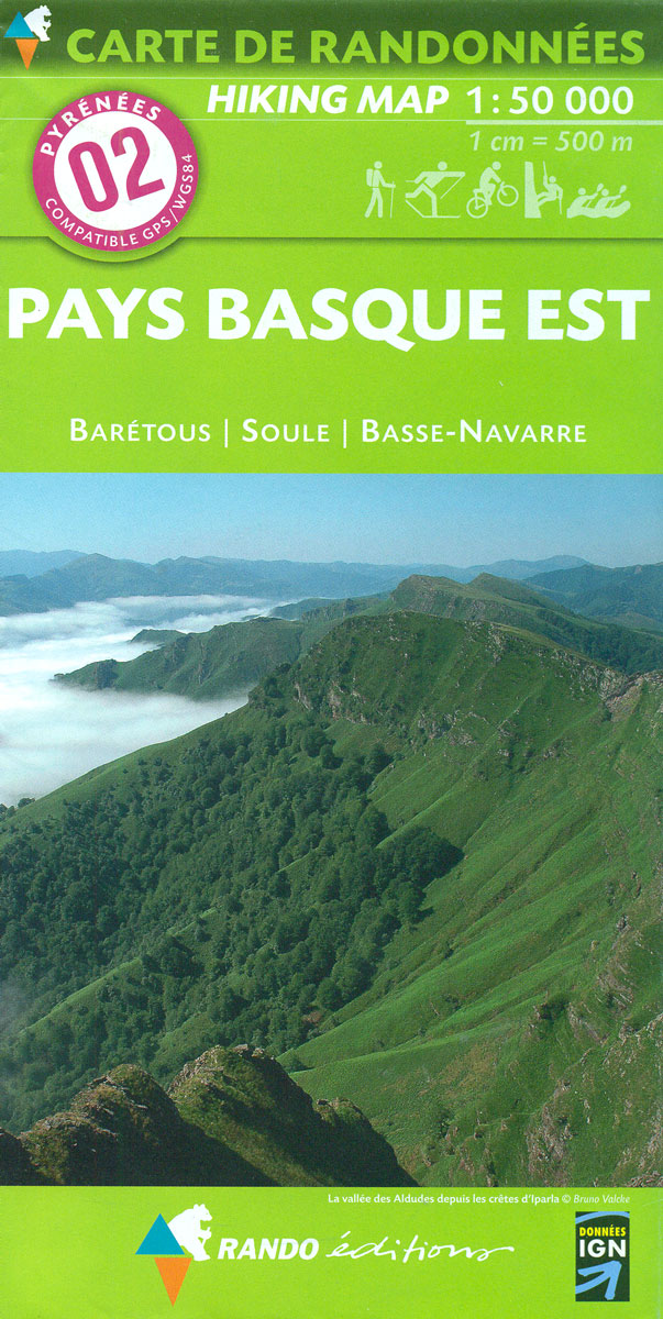
Western Pyrenees in France from the peaks of Iguzuki and Iparla, across St-Jean-Pied-de-Port and Larrau, to Pic d’Anie on a contoured and GPS compatible map at 1:50,000 from Rando Editions with topographic base provided by the IGN, highlighting local and long-distance hiking trails, cycle and mountain bike routes, etc. Topography is vividly presented by contours at 20m intervals enhanced by shading and graphic relief, plus colouring for woodlands and brushwood. An overprint highlights waymarked local and long-distance trails, including the course of the GR10, as well as other hiking paths, indicating difficult sections. The map also highlights recommended cycling and mountain biking routes. A wide range of symbols presents different accommodation options (campsites, mountain refuges or lodges, gรฎtes d’etape), locations for various recreational pursuits (mountain biking, climbing, hand gliding, canoeing and rafting, etc), historical and cultural sites, tourist information offices, etc. On the Spanish side of the border, main hiking trails are highlighted but other recreational and tourist information is limited. The map has a 2km UTM grid and its map legend includes English.To see the list of titles in this series please click on the series link.

Related Products:
 Pays Basque West Rando Editions 1
 Luchon Rando Editions 5
 Bรฉarn – Aspe – Ossau – Pyrenees National Park Rando Editions 3
 Canigou-Garrotxa Rando Editions 10
 Le Sentier Cathare – Queribus – Peyrepertuse Rando Editions 9
 Bigorre – Cauterets – Gavarnie – Saint-Lary-Soulan – Pyrenees NP Rando Editions 4
 Gavarnie-Ordesa Rando Editions 12
 Couserans-Val d`Aran Rando Editions 6
 Haute-Ariรฉge Rando Editions 7
 Cerdagne-Capcir Rando Editions 8
 France: Rando Editions/IGN 50K Walking Maps of the Pyrenees
 Collioure-Cadaquรฉs Rando Editions 11
 Finistรจre Sud – Quimper ‘“ Douarnenez ‘“ Pont-l’Abbรฉ Rando Editions
 Basque Country IGN 75023
 Mt Parnitha Terrain Editions 239
 Beaufortain Rando Editions
Vanoise Rando Editions
Ecrins Rando Editions
Beaufortain Rando Editions
Vanoise Rando Editions
Ecrins Rando Editions
 Mont Blanc Rando Editions
 Belledonne Rando Editions
 Ile d`Olรฉron – Ile de Rรฉ Rando Editions
France: Rando Editions 50K Walking Maps of the French Alps
Ile d`Olรฉron – Ile de Rรฉ Rando Editions
France: Rando Editions 50K Walking Maps of the French Alps
 Greece: Terrain Editions Maps for Hiking and Recreational Pursuits
France: IGN 75K/25K TOP75 Recreational Maps
Greece: Terrain Editions Maps for Hiking and Recreational Pursuits
France: IGN 75K/25K TOP75 Recreational Maps
 Cรฉvennes – Gorges du Tarn IGN 75011
 Gorges and Monts d`Ardรจche IGN 75014
 Perigord Noir – Haut-Quercy IGN 75026
 Cรฉzallier – Monts du Cantal IGN 75016
 Foret d`Orient – Lac du Der-Chantecoq IGN 75039
 Mallorca Central Plain – East and South Coasts Editorial Alpina
 Lake Geneva and Mont Blanc IGN 75007
 Chartreuse – Belledonne IGN 75002
Gavarnie – Neouvielle – Luchonnais – Pic du Midi de Bigorre IGN 75019
Chartreuse – Belledonne IGN 75002
Gavarnie – Neouvielle – Luchonnais – Pic du Midi de Bigorre IGN 75019
 Haut-Languedoc IGN 75022
Pelion Central Terrain Editions 218
Haut-Languedoc IGN 75022
Pelion Central Terrain Editions 218
 Pyrรฉnรฉes Ariรฉgeoises – Mont Valier – Pique d`Estats IGN 75020
 Pyrรฉnรฉes Catalanes – Font-Romeu – Massif du Canigou IGN 75021
 El Moncayo Editorial Piolet
 Chaรฎne des Puys – Massif du Sancy IGN 75015
 Pointe du Raz – Presqu`รฎle de Crozon – Ouessant – les Abers IGN 75024