Disclosure : This site contains affiliate links to products. We may receive a commission for purchases made through these links.
Patagonian & Fuegian Channels – Chilean Fjords Cruise Chart

Patagonian and Fuegian Channels: Chilean Fjords Cruise Chart from the Buenos Aires based Zagier & Urruty is designed to show travelers along this intricate coastline routes taken by cruise ships, names of fjords and islands, etc, and printed on light, waterproof and tear resistant synthetic paper.Coverage of the Chilean coastline starts at Boca del Guafo and continues south to Cape Horn and then along the coast of Tierra del Fuego to the Straights of Magellan. The main map at 1:1,400,000 is supplemented by five insets showing in greater much greater detail the most interesting areas: two panels with the Beagle Channel from the Pacific to beyond Ushuaia, the Agostini Fjord, the Wulaia Inlet and the Orange Bay. Numerous islands, fjords and peninsulas are named, as well as main towns along the coast. Topography is presented only by graphics showing the glaciers, but beautiful, evocative drawings of the kind used in old atlases show many of the most interesting coastal features. The map is decorated by more drawings of ships involved in early explorations of this region. Also provided is a glossary of geographical terms used on the map and a panel for logging cruise dates.Please note: this map is not a maritime chart for navigation.This title is part of the publishers’ series of maps of Patagonia and its most visited regions.

Related Products:
 Western Fjords
 Berlitz: Cruising & Cruise Ships 2020
 Admiralty Chart Folio 97 – Magellan Strait, Cape Horn, Patagonian Channels and Arctic Peninsula
 Caribbean Cruise Ports Marco Polo Pocket Guide – with pull out maps
 Canary Islands Cruise Ports Marco Polo Pocket Guide – with pull out maps
 Iceland Western Fjords
 The Cruise Handbook
 The Unofficial Guide to the Disney Cruise Line 2019
 The British Cruise Ship: An Illustrated History 1945-2014
Dubrovnik & Croatian Coast Cruise ITMB Street Plan and Regional Map
The British Cruise Ship: An Illustrated History 1945-2014
Dubrovnik & Croatian Coast Cruise ITMB Street Plan and Regional Map
 Mediterranean Cruise Ports Marco Polo Pocket Guide – with pull out maps
Navigator Guide to to the Chilean Patagonia
Mediterranean Cruise Ports Marco Polo Pocket Guide – with pull out maps
Navigator Guide to to the Chilean Patagonia
 The Fjords Nordeca Sightseeing Map 6024
Fodor`s European Cruise Ports of Call: Top cruise ports in the Mediterranean, Aegean, and Northern Europe
The Fjords Nordeca Sightseeing Map 6024
Fodor`s European Cruise Ports of Call: Top cruise ports in the Mediterranean, Aegean, and Northern Europe
 Admiralty Chart 4035 – Western Anchorage, Jong Fairway and Cruise Bay
 Cruise Guide to Europe and the Mediterranean Eyewitness Guide
 Rick Steves Scandinavian & Northern European Cruise Ports
 Patagonian South Icefield – Monte Fitz Roy
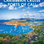
 Caribbean Cruise Ports Of Call
CHS Chart 7212 – Bylot Island and Adjacent Channels
Caribbean Cruise Ports Of Call
CHS Chart 7212 – Bylot Island and Adjacent Channels
 Cruise Ports Caribbean
 Baltic Sea Cruise Ports Marco Polo Pocket Guide – with pull out maps
 Cruise Ship Sos
 Cruise Ports Scandinavia & Northern Europe
 Admiralty Chart 468 – Cruise Terminals in the Caribbean: Amber Cove, Dominican Republic and Grand Turk, Turks and Caicos
Berlitz Cruise Guide
Admiralty Chart 468 – Cruise Terminals in the Caribbean: Amber Cove, Dominican Republic and Grand Turk, Turks and Caicos
Berlitz Cruise Guide
 Racundra`s Third Cruise
 Lonely Planet Cruise Ports Northeast Asia
 CHS Chart 6436 – Napoiak Channel, including Schooner and Taylor Channels Kilometre 1590-1650
 Fodor`s Essential Argentina: with the Wine Country, Uruguay & Chilean Patagonia
 Skaftafell
 NOAA Chart 19351 – Channels between O’ahu, Moloka`i and Lana`i – Kaumalapu Harbor
Cruise of the “Conrad”
NOAA Chart 19351 – Channels between O’ahu, Moloka`i and Lana`i – Kaumalapu Harbor
Cruise of the “Conrad”
 Cruise Ports Alaska
 Rick Steves Mediterranean Cruise Ports (Fifth Edition)
 Rick Steves Northern European Cruise Ports
 Fodor`s Caribbean Cruise Ports of Call
 Nevado Ojos del Salado Alpenverein 0/13
 NOAA Chart 19347 – Channels between Moloka’i, Maui, Lana`i and Kaho`olawe – Manele Bay
 Akureyri – Mรฝvatn – Dettifoss