Disclosure : This site contains affiliate links to products. We may receive a commission for purchases made through these links.
Parkhead 1897 – 6.16

Parkhead area of Glasgow in 1897 in a fascinating series of reproductions of old Ordnance Survey plans in the Alan Godfrey Editions, ideal for anyone interested in the history of their neighbourhood or family.The map covers an area of south-east Glasgow which includes much of Parkhead and Dalmarnock and extends out to Braidfauld. Coverage stretches from Westmuir Street southward to Westhorn House and St Peter`s Cemetery Braidfauld, and from Boden Street eastward to Tollcross House. Features include Celtic Park football ground, Parkhead station, Barrowfield Potteries, part of Eastern Necropolis, Belvidere Hospital, Dalmarnock Weaving Factory, Springfield Dye Works, Dalmarnock Paper Mills, Dalmarnock Hair Factory, Summerfield Works, Anchor Brewery, Caledonian Iron Works, Mauldslie Brickworks, Springfield Wire Works, Westhorn Brick Works, Westhorn Farm, Convent of the Good Shepherd, Maukinfauld, Burnbrae, etc. On the reverse are street directory extracts for Great Eastern Road and London Road, plus bye-laws and rates for hackney carriages, chimney sweeps and city porters.About the Alan Godfrey Editions of the 25″ OS Series:Selected towns in Great Britain and Ireland are covered by maps showing the extent of urban development in the last decades of the 19th and early 20th century. The plans have been taken from the Ordnance Survey mapping and reprinted at about 15 inches to one mile (1:4,340). On the reverse most maps have historical notes and many also include extracts from contemporary directories. Most maps cover about one mile (1.6kms) north/south, one and a half miles (2.4kms) across; adjoining sheets can be combined to provide wider coverage.FOR MORE INFORMATION AND A COMPLETE LIST OF ALL AVAILABLE TITLES PLEASE CLICK ON THE SERIES LINK.

Related Products:
 Glasgow Green 1892
Glasgow East End 1893
Glasgow Green 1892
Glasgow East End 1893
 Dumbarton 1897
Coatdyke 1897 – 8.09
Motherwell (East) 1897 – 12.14
Carmyle 1934
Port Sunlight and Bebington 1897
Dumbarton 1897
Coatdyke 1897 – 8.09
Motherwell (East) 1897 – 12.14
Carmyle 1934
Port Sunlight and Bebington 1897
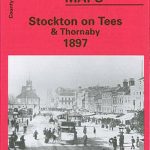 Stockton on Tees & Thornaby 1897 – 50.16a
Coatbridge 1897
Stockton on Tees & Thornaby 1897 – 50.16a
Coatbridge 1897
 Hazel Grove 1897
 Swansea 1897 – 24.05
Craigendoran and Helensburgh East 1897
Timperley 1897
Swansea 1897 – 24.05
Craigendoran and Helensburgh East 1897
Timperley 1897
 The Falls 1931 – 60.12
Bothwell & Blantyre 1897 – 11.11
Rutherglen East 1910
Uddingston 1897 – 11.07
The Falls 1931 – 60.12
Bothwell & Blantyre 1897 – 11.11
Rutherglen East 1910
Uddingston 1897 – 11.07
 St Albans South-West 1897
Lenzie 1897
Tow Law 1897
St Albans South-West 1897
Lenzie 1897
Tow Law 1897
 Swansea (North) 1897 – 24.01
Durham City South 1897
Swansea (North) 1897 – 24.01
Durham City South 1897
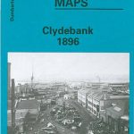 Clydebank 1896
Newtownards 1901
Glasgow St Rollox 1933
Central Glasgow 1934 – 6.10c
Central Glasgow 1893 – 6.10a
Central Glasgow 1909 – 6.10b
Clydebank 1896
Newtownards 1901
Glasgow St Rollox 1933
Central Glasgow 1934 – 6.10c
Central Glasgow 1893 – 6.10a
Central Glasgow 1909 – 6.10b
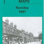 Romiley 1897
Glasgow North East 1893
Stonefield, Auchinraith & Burnbank 1897 – 11.15
St Rollox 1894 – 6.07a
Romiley 1897
Glasgow North East 1893
Stonefield, Auchinraith & Burnbank 1897 – 11.15
St Rollox 1894 – 6.07a
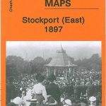 Stockport East 1897
Glasgow High Street 1909
Glasgow High Street 1933
Barnard Castle 1897 – 52.04a
Kelvinside 1893
Hamilton Low Parks 1897
Rutherglen West and Polmadie 1910
Sacriston 1897
Stockport East 1897
Glasgow High Street 1909
Glasgow High Street 1933
Barnard Castle 1897 – 52.04a
Kelvinside 1893
Hamilton Low Parks 1897
Rutherglen West and Polmadie 1910
Sacriston 1897