Disclosure : This site contains affiliate links to products. We may receive a commission for purchases made through these links.
Papua & Maluku Islands Nelles
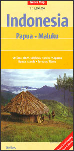
The easternmost part of Indonesia at 1:1,500,000 from Nelles, with separate panels presenting various groups of islands plus Indonesian Papua (Irian Jaya). Enlargements at more detailed scales show the more frequently visited islands of this remote part of Indonesia. On one side is the whole of the Indonesian Papua and the adjoining island groups, including Aru, Kai and Tayandu. On the reverse separate panels show at 1:1,500,000:- The Maluku (Moluccas, Moluccan) Islands from north-eastern Sulawesi to the western tip of Papua, including Sula Islands, Halmahera (Jailolo), Bacan Islands, Obi, Buru, Seram (Ceram), Waigeo, Raja Islands and Misool. Enlargements cover in greater detail: Ternate and Tidore Islands at 1:380,000, plus Ambon with Haruku and Saparua at 1:500,000.- The Western Daya Islands, including the eastern part of East Timor, Wetar, Leti Islands, Sermata Islands, Babar Islands and Damar Islands.- The Arafura Sea groups of islands: Tanimbar, Tayandu, Kai and Aru.- Banda Islands (Nutmeg Islands) are shown separately at 1:250,000.Relief shading with spot heights and names of peaks presents each island’s topography. The map shows the road network, plus local airports and ferry connections. National parks or protected areas and numerous places of interest are prominently highlighted. Latitude and longitude are indicated by margin ticks at 1ยฐ intervals (30’ on the enlargements). The map has no index of localities or individual islands. Map legend includes English.To see other maps from Nelles covering the islands of Indonesia please click on the series link.

Related Products:
 Papua New Guinea – Indonesian Papua & Maluku Islands Reise Know-How
 New Guinea (Papua New Guinea and Indonesia) ITMB
 South Pacific Islands Nelles
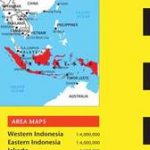
 Indonesia: Nelles Regional Maps
 Lonely Planet Papua New Guinea and Solomon Islands
 Okinawa & the Ryukyu Islands Periplus Travel Map
 Japan Nelles
 Diving in Indonesia: The Ultimate Guide to the World`s Best Dive Spots: Bali, Komato, Sulawesi, Papua, and More
 USA: Nelles Maps of the Hawaiian Islands
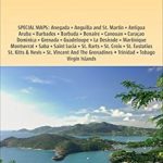
 Caribbean – Central America – Virgin Islands – Bahamas
 Papua New Guinea Hema
 NGA Chart 82015 – Solomon Islands [Papua New Guinea and Solomon Islands]
 Southeast Asia Nelles
 Lesser Sunda Islands – Bali to East Timor Reise Know-How
 Indonesia Periplus Travel Map
Sulawesi – Nusa Tenggara – East Timor Nelles
Indonesia Periplus Travel Map
Sulawesi – Nusa Tenggara – East Timor Nelles
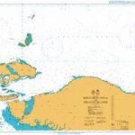 Admiralty Chart 3923 – North West Papua and Adjacent Islands
 Caribbean – Lesser Antilles Nelles
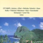 Hawaii – Maui – Molokai – Lanai Nelles
 Polynesian Islands ITMB Travel Atlas
 NP35 Indonesia Pilot Vol 3 2021
 Java – Jakarta Nelles
Hawaii – Kauai Nelles
Java – Jakarta Nelles
Hawaii – Kauai Nelles
 ADMIRALTY Total Tide Area 7 – Australia, Indonesia & Papua New Guinea – 12 Months
 Bali – Lombok Nelles
 Borneo – Malaysia East – Brunei – Kalimantan Nelles
 Tahiti & Cook Islands ITMB
 Hawaii Easy-to-Read Rand McNally
 Flag of Papua New Guinea
Hawaii – The Big Island Nelles
Flag of Papua New Guinea
Hawaii – The Big Island Nelles
 NP33 Philippine Islands Pilot 2021
 Indonesian Cooking: Satays, Sambals and More: Homestyle Recipes with the True Taste of Indonesia
 The South Sandwich Islands Volcanic Arc BAS Bathymetry and Geological Map 6
 Canary Islands
 Indonesia: Periplus Regional Maps
 Hawaiian Islands Nelles
 Fiji & Tonga ITMB
 Cayman Islands & Jamaica ITMB
 Papua New Guinea