Disclosure : This site contains affiliate links to products. We may receive a commission for purchases made through these links.
Panama NGS Adventure Map 3101
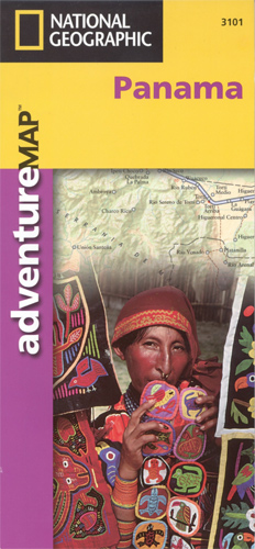
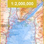
Double-sided, waterproof and tear-resistant map with a street plan of central Panama City and an enlargement of the Panama Canal region. The country is divided east/west, with a generous overlap between the two sides. Relief is shown by contours at 100m intervals, enhanced by hill-shading and spot heights. The map indicates forests, mangroves, swamps and coral reefs. Road detail emphasises the Pan-America Highway and includes primary and secondary roads and trails. Intermediate road distances are marked on main routes. Railways, sea ferries, airports and airstrips are marked, as well as the country’s internal administrative boundaries together with names of the provinces. The country’s various national parks and other types of protected area are marked, and symbols denote archeological sites and other sites of interest, ports, border crossings and fishing, diving and surfing sites. A UTM grid is printed on the map, plus latitude and longitude margin ticks at 20` intervals. An index lists the protected areas and a selection of towns, and the map is annotated with facts various localities and aspects of the country’s geography.The map includes a street plan of central Panama City, naming principal streets and districts, and highlighting various notable buildings, places of interest to visitors, embassies, hospitals and churches. There is a further enlargement of the historic heart – San Felipe. The Panama Canal region is shown at 1:165,000, indicating more places of interest, the shipping lane and the canal locks.

Related Products:
 Panama ITMB
 Panama Canal & Central Panama ITMB
 Cape Town & Peninsula NGS Adventure Map 3200
 Pan-Americana North ITMB Travel Atlas: Alaska to Panama
 Namibia Map Studio Adventure Map
 Costa Rica Borch
 Costa Rica – Panama Reise Know-How
 Northern Yucatan Peninsula NGS Adventure Map 3105
 Central America ITMB
 Belize Borch
 The Panama Guide: A Cruising Guide to the Isthmus of Panama
 Southern Baja California NGS Adventure Map 3104
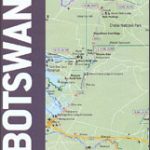 Botswana Map Studio Adventure Map
 Puerto Rico NGS Adventure Map 3107
 Belize NGS Adventure Map 3106
 Lisbon Borch
 The Rough Guide to Panama
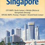 Malaysia West – Singapore Nelles
 Albany City & County, NY
 Central America – Caribbean Islands – Mexico
 Ecuador Borch
 Red Sea Gizi Map
 Red Sea Wall Map
 Costa Rica NGS Adventure Map 3100
 Czech Republic ITMB
 Northern Baja California NGS Adventure Map 3103
 Nepal Nelles
 Cuba Michelin
 Thailand, Vietnam, Laos & Cambodia ITMB Travel Atlas
 Rennes and its Environs IGN Map
 Lithuania Jana Seta Compact Road Atlas
 Western Cape Map Studio
 Ukraine – Moldova Gizi Map
 Kenya ITMB
 Annapurna NGS Adventure Map 3003
 Langtang NGS Adventure Map 3004
 Beijing Borch
 Bangladesh & India East ITMB