Disclosure : This site contains affiliate links to products. We may receive a commission for purchases made through these links.
Paklenica National Park
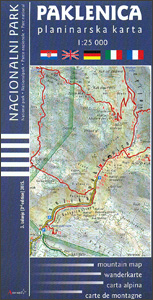
Paklenica National Park on the Croatian coast near Zadar on a detailed, contoured and GPS compatible map at 1:25,000 from Astroida, highlighting waymarked hiking paths and cycling routes both within the park and outside its boundary, plus on the reverse notes about the park.The map covers both the Velika and the Mala Paklenica Canyons and the surrounding area, presenting the topography by contours at 10m intervals plus relief shading, colouring and/or graphics indicating woodlands, meadows, etc. The overprint highlights 50 waymarked hiking paths, with their numbers cross-referenced to a list on the map cover indicating timing, degree of difficulty, etc. The map also shows recommended cycling trails. Road network indicates locations of petrol stations and car repair facilities. Symbols highlight various places of interest including campsites and mountain huts, information offices, etc. Along the coast beaches and marinas are marked. The map has a 1-km UTM grid, plus latitude and longitude margin ticks at 1’ intervals. Map legend includes English.On the reverse there are multilingual notes about the park plus adverts for local accommodation, etc.

Related Products:
 Paklenica National Park Croatian Mountain Rescue Service 25K Map
 Skadar Lake National Park
 Biebrza National Park ENGLISH
 Drawienski (Drawno) National Park
Puszcza Kampinoska – Kampinoski National Park
Drawienski (Drawno) National Park
Puszcza Kampinoska – Kampinoski National Park
 Bialowieza / Puszcza Bialowieska National Park
 Fruลกka Gora National Park
 Triglav National Park Kartografija WATERPROOF Hiking Map
 Banff National Park Gem Trek
 Tara National Park
 Monti Sibillini National Park Edizioni Multigraphic 60/61
 Aukstaitija National Park
 Kootenay National Park Gem Trek Map
 Bavarian Forest National Park – Nature Park East UK50-29
 Berchtesgaden National Park – Watzmann Alpenverein KOMBI BY21
 Mavrovo National Park
 Thayatal National Park – Znaim – Retz – Gars am Karp Freytag & Berndt Map
 Lastovo Islands Nature Park
Slowinski National Park ExpressMap Tourist Map
Lastovo Islands Nature Park
Slowinski National Park ExpressMap Tourist Map
 Pyhrn-Priel – Grรผnau – Almtal – Steyral – Kalkalpen National Park – Bad Aussee F&B WK081
 Donana National Park CNIG Map-Guide SPANISH
 Osogovski National Park
Skaftafell National Park IDNU Map
Osogovski National Park
Skaftafell National Park IDNU Map
 Jasper National Park & Northern Alberta ITMB
Dzukija National Park East
Dzukija I National Park West
Jasper National Park & Northern Alberta ITMB
Dzukija National Park East
Dzukija I National Park West
 Yosemite National Park Area
 Garajonay National Park – Gomera CNIG Map-Guide ENGLISH
 Lemmenjoki National Park
 Triglav National Park
 Aigรผestortes and Estany de Sant Maurici National Park 2-Map Set Editorial Alpina
 Bรฉarn – Aspe – Ossau – Pyrenees National Park Rando Editions 3
 Garajonay National Park – Gomera CNIG Map-Guide SPANISH
Zemaitija National Park
Garajonay National Park – Gomera CNIG Map-Guide SPANISH
Zemaitija National Park
 Sareks National Park Lantmateriet BD10
 Waterton Lakes National Park Gem Trek Map
 Belgian Ardennes: Malmedy – Hautes Fanges National Park
 Bansko (with Pirin National Park)
 Galicica National Park
 Discover Cairngorms National Park