Disclosure : This site contains affiliate links to products. We may receive a commission for purchases made through these links.
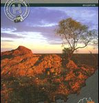
Outback Queensland – Camooweal to Stanthorpe Hema Explorer Map
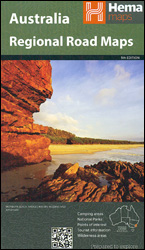
Outback Queensland on touring map at 1:1,1,500,000 from Hema highlighting 19 recommended tourist routes, with on the reverse eight panels showing the region’s most popular national parks in greater detail, plus a table with tourist facilities in 24 national parks, descriptions of places of interest, etc. The map covers the south-western part of Queensland, including the deserts in the north-eastern corner of South Australia, extending east to Toowoomba and along the coast to Mackay, Rockhampton and Gladstone, plus north to Mount Isa and the Flinders Highway.Topography is well presented by relief shading with plenty of names of mountain ranges, peaks, etc, plus colouring and/or graphics for areas liable to inundation, sand ridges, salt flats, national parks and other protected or restricted entry areas, etc. Road network indicates unsealed roads, clearly shows road numbers and names, and gives locations of fuel supply points. Outback roads and tracks indicate routes which have been GPS-plotted by the publishers themselves during fieldwork. On overprint highlights 19 recommended tourist routes. Railway lines are shown with stations and airfields/airstrips are marked, indicating Flying Doctors Service Bases. Symbols mark tourist information centres, various roadside rest areas, campsites and bush camping sites, general stores and car repair facilities, etc. Latitude and longitude lines are drawn at 1ยฐ intervals. The index is on the reverse side which also includes panels showing in greater detail most visited national parks: Diamantina, Idalia, Currawinya, Bladensburg and Carnarvon, with three further enlargements of the Carnarvon Gorge. Also provided is a table showing tourist facilities in the region’s national parks, a list of contact details for Visitor Information Centres, plus extensive notes about places of interest illustrated with colour photos.To see other titles in Hema’s series of detailed regional road maps of Australia please click on the series link.

Related Products:
 Outback Queensland Hema
 Central Queensland Hema
 North Queensland – from Cape York to Mackay Hema Explorer Map
 Central Queensland – Hervey Bay to Mackay Hema
South East Queensland – featuring Landcruiser Mountain Park Hema Explorer Map
Central Queensland – Hervey Bay to Mackay Hema
South East Queensland – featuring Landcruiser Mountain Park Hema Explorer Map
 Queensland Hema
 South East Queensland Hema
 Outback New South Wales – from Broken Hill to Tamworth Hema Explorer Map
 Queensland Hema Handy Map
North East New South Wales – Coffs Harbour to Brisbane Hema Explorer Map
Queensland Hema Handy Map
North East New South Wales – Coffs Harbour to Brisbane Hema Explorer Map
 Savannah Way – Cairns to Broome Hema Touring Map
 Sydney to Brisbane Hema
 Central Australia Hema 4WD Explorer Map
 Brisbane to Cairns Hema
 South West Western Australia Hema
 North East New South Wales Hema
 Melbourne to Sydney Hema
 Melbourne to Adelaide – featuring the Great Ocean Road and Victorian Goldfields Hema Touring Map
 Brisbane & Queensland ITMB
 Western Australia Hema
 Victoria Hema
 New South Wales Hema
 North Island – New Zealand Hema
 South Australia Hema
 South East Queensland – 4WD + Camping Escapes Atlas & Guide A4 SPIRAL-BOUND
South Island – New Zealand Hema
South East Queensland – 4WD + Camping Escapes Atlas & Guide A4 SPIRAL-BOUND
South Island – New Zealand Hema
 Australia Hema Road & 4WD Atlas PAPERBACK
 Pilbara and Coral Coast Hema Waterproof Map
 Mid West Western Australia Hema
Tasmania Hema
Mid West Western Australia Hema
Tasmania Hema
 Northern Territory Hema
 Australia Hema Road & 4WD Touring Atlas A4 SPIRAL-BOUND
 Western Australia Hema Road & 4WD Track Atlas A4 SPIRAL-BOUND
 Australia Hema Handy Atlas SPIRAL-BOUND
 Australia: Hema City to City Road Maps
 Australia: Hema State Road Maps
 Red Centre – Alice Springs to Uluru NT Hema
 Top End National Parks: Litchfield – Katharine – Kakadu Hema
 Top End and Gulf Hema Waterproof Map
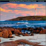 South West Corner – Margaret River & Southern Forest Hema