Disclosure : This site contains affiliate links to products. We may receive a commission for purchases made through these links.
Ossett Central 1890

Central Ossett in 1890 in a fascinating series of reproductions of old Ordnance Survey plans in the Alan Godfrey Editions, ideal for anyone interested in the history of their neighbourhood or family. Two versions have been published for this area, extending southward to Sowood Farm and Ossett Spa, and eastward to Haggs Lane. Features include town centre with Market Place, Grammar School, railway with Ossett station, South Ossett, Victoria Mills, Christ Church, Storrs Hill, Giggal Hill, Croft House, rag warehouses, Manor Mill, Barmby Fold, Ossett Spas, Spring Field Mills, Hope Mill, Low Common, Wakefield & District Tramway, Wesley House, Storrs Hill Mill, Haggs Hill, chapels, schools, etc. Selections from an Ossett trade directory are on the reverse of the 1905 map. About the Alan Godfrey Editions of the 25″ OS Series:Selected towns in Great Britain and Ireland are covered by maps showing the extent of urban development in the last decades of the 19th and early 20th century. The plans have been taken from the Ordnance Survey mapping and reprinted at about 15 inches to one mile (1:4,340). On the reverse most maps have historical notes and many also include extracts from contemporary directories. Most maps cover about one mile (1.6kms) north/south, one and a half miles (2.4kms) across; adjoining sheets can be combined to provide wider coverage.FOR MORE INFORMATION AND A COMPLETE LIST OF ALL AVAILABLE TITLES PLEASE CLICK ON THE SERIES LINK.

Related Products:
 Ossett Central 1905
Horbury 1905
Barnsley 1890 (Colour Edition)
South Yardley and Hay Mills 1903
Ossett Central 1905
Horbury 1905
Barnsley 1890 (Colour Edition)
South Yardley and Hay Mills 1903
 Leeds Central and North East 1890
Central Liverpool 1890 – 106.14a Colour Edition
Bolton South and Great Lever 1927
Wakefield (South) 1890 – 248.07a
Leeds Central and North East 1890
Central Liverpool 1890 – 106.14a Colour Edition
Bolton South and Great Lever 1927
Wakefield (South) 1890 – 248.07a
 Bolton North 1908
 East Bierley 1905
 Bradford Odsal & Low Moor 1905
Holmfirth 1904
Accrington 1909
Blackburn 1929
Blackburn 1910
Central Croydon 1895 – 14.10
Bradford Odsal & Low Moor 1905
Holmfirth 1904
Accrington 1909
Blackburn 1929
Blackburn 1910
Central Croydon 1895 – 14.10
 Godalming 1895
Leeds South and South East 1890 (Colour Edition)
Pollok Park 1909
Godalming 1895
Leeds South and South East 1890 (Colour Edition)
Pollok Park 1909
 Blackburn 1892 (Coloured Edition)
 Mill Hill Village 1898
Halifax: Mixenden and South Illingworth 1905
Halifax Ovenden Cross 1905
Hurst and North Ashton 1906
Mill Hill Village 1898
Halifax: Mixenden and South Illingworth 1905
Halifax Ovenden Cross 1905
Hurst and North Ashton 1906
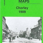 Chorley 1909
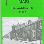 Barnoldswick 1907
Aberdeen (Bridge of Don) 1899 – 75.03
Wakefield (North) 1890 – 248.03a
Barnoldswick 1907
Aberdeen (Bridge of Don) 1899 – 75.03
Wakefield (North) 1890 – 248.03a
 Chadderton North 1932
 Heywood 1907
Ivybridge 1905
Heywood 1907
Ivybridge 1905
 Bollington 1907
Blackburn West 1929
Blackpool Central Pier 1909
Horwich North 1907
Farington South and Leyland North 1909
Marsden 1904
Wrexham Central 1909
Bollington 1907
Blackburn West 1929
Blackpool Central Pier 1909
Horwich North 1907
Farington South and Leyland North 1909
Marsden 1904
Wrexham Central 1909
 Bradford Central 1906
Ashton-under-Lyne 1916
Bradford Central 1906
Ashton-under-Lyne 1916