Disclosure : This site contains affiliate links to products. We may receive a commission for purchases made through these links.
Orlando & Central Florida ITMB
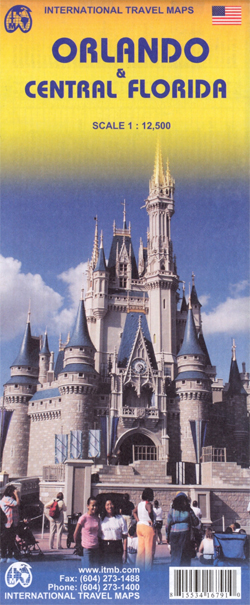
ITMB’s Orlando and Central Florida combines a coast-to-coast road map of the central part of the state with four more detailed maps: Disney World, International Drive with the Sea World, a large plan of central Orlando, and a map of the wider region of the city including access to Disney World.On one side is a road map at 1:400,000 of the central part of Florida covering the Space Coast and the Treasure Coast between Edgewater and Jupiter on the Atlantic side, and the Sun Coast plus the Nature Coast on the Gulf of Mexico, including Saint Petersburg, Tampa and Sarasota. Road network is neatly presented with road numbers on all roads and driving distance on federal and state highways. Toll plazas, services and rest areas are indicated and exits from main highways are clearly numbered. The map also shows railway lines and local airports, plus indicates locations of numerous places of interest, including the area’s main attractions, with some places annotated with brief descriptions, national parks and state forest or other protected areas, Indian Reservations and military zones, etc. The map is indexed, but has no geographical coordinates.Two thirds of the reverse side are taken up by a clear, indexed street plan of the central districts of Orlando at 1:12,500, extending from the theatres in the Orlando Loch Haven Park to Kaley Street on the south and from Sunset Lake in the west to the Orlando Festival Park. Hotels, places of worship, etc. are highlighted. A wider region around the city is presented on a road map at 1:150,000 with main highways and connecting roads to the area’s numerous attractions. Also included is a plan of the Walt Disney World Resort at 1:44,000 and a map of the International Drive area including the Sea World, both annotated with hotels and sights.To see other regional titles from ITMB covering USA please click on the series link.

Related Products:
 Florida Central & Eastern Regional Rand McNally
 Orlando Borch
 Florida Hildebrand`s Road Map
 Orlando PopOut
 Florida F&B
 Miami & South Florida ITMB
 Lima & Central Peru ITMB
 Florida & US Deep South ITMB
 Orlando FL Rand McNally
 Philadelphia & Mid-Atlantic States ITMB
 USA South: Atlantic States ITMB
 Kyoto & Japan West ITMB
 Tokyo & Central Japan ITMB
 Tel Aviv-Jaffa & Central Israel ITMB
 Florida Easy-to-Read Rand McNally
Sydney & Australia East ITMB
Florida Easy-to-Read Rand McNally
Sydney & Australia East ITMB
 Lonely Planet Pocket Orlando & Walt Disney World Resort
 Quito & Central Ecuador ITMB
 Manhattan & New York State ITMB
 Osaka & Western Japan ITMB
 Fodor`s Walt Disney World: With Universal & the Best of Orlando
 Zurich & Switzerland NW ITMB
 Iran & Tehran ITMB
 Sao Paulo & Brazil South Coast ITMB
 Southeast USA – The South & Florida Borch
 Havana & Cuba Central ITMB
 Frommer`s EasyGuide to Disney World, Universal and Orlando 2020
 Southern Ontario ITMB
 Saudi Arabia & Kuwait ITMB
 Toronto & Southern Ontario ITMB
 Los Angeles & Southern California ITMB
 Bangladesh & India East ITMB
 Central USA & the Mississippi River ITMB
Florida Keys Adventure & Dive Map-Guide
Central USA & the Mississippi River ITMB
Florida Keys Adventure & Dive Map-Guide
 Seattle & Northwest USA ITMB
Sri Lanka & India South ITMB
Seattle & Northwest USA ITMB
Sri Lanka & India South ITMB
 Montreal & Southern Quebec ITMB
 San Diego & USA South West Border ITMB