Disclosure : This site contains affiliate links to products. We may receive a commission for purchases made through these links.
Ontario South Central – Toronto – Niagara Falls – Kitchener-Wateroo Mapart Back Road Map
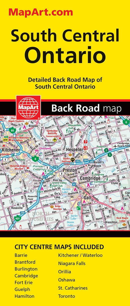
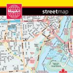
The south-central part of Ontario on a detailed, double-sided road map at 1:250,000 extending from Niagara Falls west to Kitchener/Waterloo and north beyond Orillia, with 13 street plans covering central Toronto, Niagara Falls, Guelph and other main cities of the region.On one side is an indexed road map showing the region at 1:250,000. Coverage extends to the Georgian Bay of Lake Huron and beyond Lake Simcoe and Orillia to Gravenhurst. Road network indicates paved, gravel and unimproved roads. Exit numbers and motorway services are clearly marked. Railway lines are included and local airports are marked. A wide range of symbols indicate campsites, tourist information offices, historic sites and various places of interest, etc. The map has a 10km UTM grid. On the reverse are 13 panels with street plans: central Toronto at 1:15,000, plus at scales 25K/28K central Barrie, Brantford, Burlington, Cambridge, Fort Eire with the Peace Bridge to Buffalo, Guelph, Hamilton, Kitchener/Waterloo, Niagara Falls with the Rainbow Bridge and access to the Falls, Orillia, Oshawa, and St. Catharines. To see the list of currently available Canadian province and regional maps form the MapArt / Canadian Cartographics Corporation / JDM Gรฉo publishing group, including waterproof and tear-resistant FastTrack titles, please click on the series link.

Related Products:
 Moon Toronto & Ontario: With Niagara Falls, Ottawa & Georgian Bay
 Toronto with Niagara Falls & the Niagara Wine Region
 Niagara Falls – Fort Erie – Niagara-on-the-Lake – Grand Island
 Fodor`s Toronto: with Niagara Falls & the Niagara Wine Region
 Ontario MapArt Pocket Road Atlas
 Moon Niagara Falls: Including the Canadian & U.S. Sides
 Toronto & Area MapArt Street Atlas
 Niagara Region (Canada) FastTrack Map
 Toronto & Southern Ontario ITMB
 Buffalo – Niagara Falls NY Rand McNally
 Ontario Southwestern: Brantford – London – Kitchener/Waterloo – Bruce Peninsula
 Moon Niagara Falls (Third Edition): With Buffalo
 Kitchener – Waterloo Street Atlas
Ontario MapArt
Kitchener – Waterloo Street Atlas
Ontario MapArt
 Ontario MapArt Back Road Atlas
 Toronto MapArt Street Plan
 Ontario Eastern MapArt
 Southern Ontario ITMB
 Toronto Borch
 Toronto Pocket Street Atlas
 Manitoba & Saskatchewan MapArt Road Atlas
 DK Eyewitness Top 10 Toronto 7/5/20
 The 500 Hidden Secrets of Toronto
 Alberta MapArt Back Road Atlas
 Ontario ITMB
 Queen of the Falls
Canada: MapArt / Canadian Cartographics Corporation Provincial and Regional Road Maps and Atlases
Queen of the Falls
Canada: MapArt / Canadian Cartographics Corporation Provincial and Regional Road Maps and Atlases
 Vancouver to Calgary MapArt Back Road Atlas
 Ontario Northern and Cottage Country Street Atlas
 Iguazu Falls de Dios Regional Map
 The Falls 1931 – 60.12
 Scotland Central & South ITMB Railway & Road Map
 Manitoba MapArt
 Concrete Toronto Map: Guide to Concrete and Brutalist Architecture in Toronto
 Fort McMurray & Towns of Central and Northern Alberta
 Quebec & Ontario ITMB Travel Atlas
 Central Europe F&B Road Atlas
 Central Silesia Hรถfer Road Map
 Central Oregon Road Biking Map & Guide
Barrie – Orillia
Central Oregon Road Biking Map & Guide
Barrie – Orillia