Disclosure : This site contains affiliate links to products. We may receive a commission for purchases made through these links.
Ontario Eastern MapArt
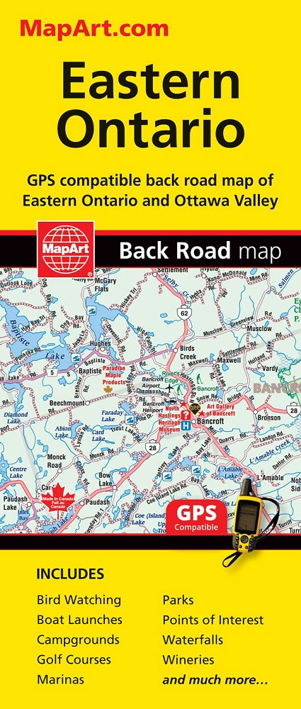
Eastern Ontario on an indexed, double-sided, GPS-compatible road map at 1:250,000 presenting the region on three panels. On one side coverage extends along the northern shore of Lake Ontario from Newcastle Village (east of Toronto and Oshawa) to Kingston and northwards to the southern access to the Algonquin Provincial Park. On the reverse two more panels extend coverage to Pembroke and Ottawa, and along the St. Lawrence River past Cornwall.Road network indicates paved, gravel and unimproved roads. Exit numbers and motorway services are clearly marked. Railway lines and ferry connections are included and local airports are marked. A wide range of symbols indicate campsites, tourist information offices, historic sites and various places of interest, etc. The map has a 10km UTM grid. To see the list of currently available Canadian province and regional maps form the MapArt / Canadian Cartographics Corporation / JDM Gรฉo publishing group, including waterproof and tear-resistant FastTrack titles, please click on the series link.

Related Products:
 Ontario South Central – Toronto – Niagara Falls – Kitchener-Wateroo Mapart Back Road Map
 Ontario MapArt Back Road Atlas
 Ontario MapArt
 Ontario Southwestern: Brantford – London – Kitchener/Waterloo – Bruce Peninsula
 Ontario MapArt Pocket Road Atlas
 Manitoba MapArt
 Ontario Northern FastTrack Map: North Bay – Sudbury – Thunder Bay – Lake of the Woods
 Ontario Western Street Atlas
 Ontario ITMB
 Toronto & Southern Ontario ITMB
 New Brunswick MapArt
 Ontario Northern and Cottage Country Street Atlas
 Quรฉbec Province MapArt
 Canada MapArt Road Atlas
 Nova Scotia MapArt
 Saskatchewan MapArt
 Central Canada: Manitoba, Saskatchewan & Eastern Ontario c.1900
 Manitoba & Saskatchewan MapArt Road Atlas
 Canada Central: Western Ontario, Manitoba, Saskatchewan Reise-Know-How Map
Canada: MapArt / Canadian Cartographics Corporation Provincial and Regional Road Maps and Atlases
Canada Central: Western Ontario, Manitoba, Saskatchewan Reise-Know-How Map
Canada: MapArt / Canadian Cartographics Corporation Provincial and Regional Road Maps and Atlases
 Southern Ontario ITMB
 Canada MapArt
 Toronto & Area MapArt Street Atlas
 Vancouver to Calgary MapArt Back Road Atlas
Ontario FastTrack
Vancouver to Calgary MapArt Back Road Atlas
Ontario FastTrack
 Alberta MapArt Back Road Atlas
 Eastern Svealand Norstedts Regional Map 3
 Western Canada MapArt
 Cape Breton Island – Sydney – Truro NS MapArt
 Vancouver Island MapArt Street Atlas
Vancouver Island – Sunshine Coast – Gulf Islands BC MapArt
Vancouver Island MapArt Street Atlas
Vancouver Island – Sunshine Coast – Gulf Islands BC MapArt
 Prince Edward Island
 British Columbia MapArt
 Quebec & Ontario ITMB Travel Atlas
 British Columbia – Alberta MapArt
 Alberta MapArt
 Hanoi – Vietnam North ITMB
 USA North-Eastern: Maine to WashingtoN DC (CT, DE, ME, MD, MA, NH, NJ, NY, OH, PA, RI, VT, WV) Reise-Know-How Map
 Eastern Crete Terrain Editions 450
Brittany – Brest – Rennes K+F Regional Road Map
Eastern Crete Terrain Editions 450
Brittany – Brest – Rennes K+F Regional Road Map