Disclosure : This site contains affiliate links to products. We may receive a commission for purchases made through these links.
Obama`s Oahu
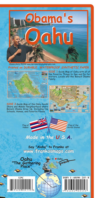
A double-sided, waterproof and tear-resistant map from Franko’s Maps combining coverage of Oahu with more detailed presentation of the island’s south-eastern area, all annotated with notes and photos of relating to Barak Obama’s life in the Makiki neighbourhood of Honolulu and his family’s visits to the island.On one side is a map of Oahu at 1:110,000 approx, with bold relief shading clearly showing its mountainous topography. Road network includes selected dirt roads and trails. The map is extensively annotated with notes about various places of interest, not just the sites connected with the President but locations such as Pearl Harbour, beaches, botanical gardens, camping sites, recreational possibilities, etc. On the reverse is a much more detailed map at 1:35,000 approx of Oahu’s South Shore Neighbourhood, extending from downtown Honolulu to the Makapuu Head, the island’s easternmost point. The Makiki district itself is also shown in greater detail on an aerial photo inset. Both panels highlight numerous locations connected with Barak Obama’s life and the Makiki panel is also overprinted with a walking tour.

Related Products:
 Oahu, Honolulu & Big Island ITMB
 Fodor`s Oahu: with Honolulu, Waikiki & the North Shore
 Hawaii – Oahu – Honolulu Nelles
 Lonely Planet Honolulu Waikiki & Oahu
 To Obama: A People`s History
 O`ahu Phears Travel Map
 Hope Rides Again: An Obama Biden Mystery
 Yes We (Still) Can: Politics in the age of Obama, Twitter and Trump
 O`ahu Island and Honolulu
 Michelle Obama: The Fantastically Feminist (and Totally True) Story of the Inspirational Activist and Campaigner
 Hope Never Dies: An Obama Biden Mystery
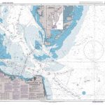
 Admiralty Chart 1309 – Hawaii to Oahu
 DK Eyewitness Top 10 Honolulu and O`ahu
 South Georgia Explorer
 Admiralty Chart 1378 – Southern Part of Oahu
 Hawaiian Islands
 Pearl Harbor Then and Now Historical Map
 Hawaiian Islands Borch
 Deacon King Kong: CHOSEN BY BARACK OBAMA AS A FAVOURITE READ
 Homeland Elegies: A Barack Obama Favourite Book
Belize Dive Map
Homeland Elegies: A Barack Obama Favourite Book
Belize Dive Map
 Intimacies: A Barack Obama Summer 2021 Reading Pick
 Eleuthera Island – Bahamas Adventure Map-Guide
 From the Corner of the Oval Office: One Woman`s True Story of her Accidental Career in the Obama White House
 Hawaii & Honolulu ITMB
 Easter Island / Rapa Nui
 Hawaii Easy-to-Read Rand McNally
Solomon Islands & South Pacific Ocean ITMB
Hawaii Easy-to-Read Rand McNally
Solomon Islands & South Pacific Ocean ITMB
 South East Queensland Hema
 South East Queensland – featuring Landcruiser Mountain Park Hema Explorer Map
 Yangzi River Odyssey Map
 Gallipoli Campaign Map and Guide
 Zanzibar Island
 Hawaii NGS Adventure Map 3111
 St Eustatius / Statia
 Camping Hawaii
 Antarctica de Dios Map-Guide
 The Kimberley – Gibb River Road Hema
South Island – New Zealand Hema
The Kimberley – Gibb River Road Hema
South Island – New Zealand Hema