Disclosure : This site contains affiliate links to products. We may receive a commission for purchases made through these links.
NZ26 East Cape to Cook Strait including Chatham Islands

Nautical charts for New Zealand, created by Land Information New Zealand (LINZ), are printed on demand at Stanfords after your order is placed and processed. They provide a detailed coverage of the coastline with a varied range of scales – from overall route planning to detailed harbour charts.Notices to Mariners are available via this link.Source: Land Information New Zealand (LINZ) and licensed by LINZ for re-use under the Creative Commons Attribution 4.0 International licence.

Related Products:
 NZ22 Kermadec Islands to East Cape
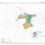 NZ268 Chatham Islands
 NZ46 Cook Strait
 NZ27 Chatham Islands to Bounty Islands
 NZ14613 Chatham Islands to Ile Rapa
 NZ14628 Cook Islands
NZ48 Western Approaches to Cook Strait
NZ14628 Cook Islands
NZ48 Western Approaches to Cook Strait
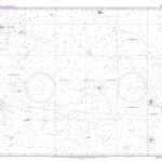
 NZ14612 Chatham Islands to Pacific – Antarctic Rise
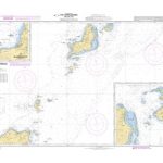
NZ2865 Plans in the Chatham Islands
NZ14612 Chatham Islands to Pacific – Antarctic Rise
NZ2865 Plans in the Chatham Islands
 NZ14630 Samoa Islands to Southern Cook Islands
 NZ14629 Samoa Islands to Northern Cook Islands and Tokelau
 NZ512 Cape Karikari to Cape Brett
 NZ14631 Samoa Islands to Tonga including Niue
 NZ14638 Fiji to Kermadec Islands including Tongatapu
 NZ14908 Cape Adare to Cape Daniell
 NZ43 Manukau Harbour to Cape Egmont
 NZ54 Cuvier Island (Repanga Island) to East Cape
 New Zealand Charts for Pacific Islands
 NZ41 North Cape
 NZ14605 New Zealand to Fiji and Samoa Islands
 NZ62 Cape Palliser / Matakitakiakupe to Kaikoura Peninsula
 NZ14912 Balleny Islands
NZ14907 Possession Islands
NZ14912 Balleny Islands
NZ14907 Possession Islands
 NZ222 Kermadec Islands
NZ5322 Auckland Harbour East
NZ222 Kermadec Islands
NZ5322 Auckland Harbour East
 NZ827 Approaches to Tongatapu including `Eua
 NZ76 Western Approaches to Foveaux Strait
 NZ286 Auckland Islands
 NZ86 Samoa Islands
 NZ955 Plans of the Cook Islands – Southern Sheet
NZ21 Norfolk Island to Cape Egmont
NZ955 Plans of the Cook Islands – Southern Sheet
NZ21 Norfolk Island to Cape Egmont
 NZ14909 Cape Hooker to Coulman Island
 NZ45 Cape Egmont to Rangitikei River
 NZ51 Tauroa Point to Cape Brett
 NZ58 Castlepoint to Cape Palliser, Matakitakiakupe
NZ72 Cape Foulwind to Heretaniwha Point
NZ58 Castlepoint to Cape Palliser, Matakitakiakupe
NZ72 Cape Foulwind to Heretaniwha Point
 NZ14901 Cape Royds to Pram Point
 NZ42 Cape Reinga / Te Rerenga Wairua to Manukau Harbour
 NZ5221 Cradock Channel and Mokohinau Islands
NZ2687 Pitt Strait
NZ5221 Cradock Channel and Mokohinau Islands
NZ2687 Pitt Strait