Disclosure : This site contains affiliate links to products. We may receive a commission for purchases made through these links.
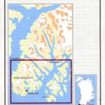
Nuuk
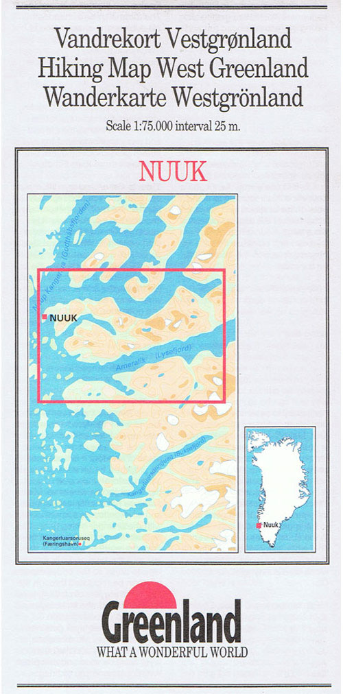
Nuuk, map no. 11, in a series of topographic maps of popular coastal areas of southern and central Greenland. Countours are shown at 25-metre intervals, with additional altitude colouring. The maps show settlements, farms, shepherds` huts, water supply areas, roads and tracks, fords, rivers and streams, etc. Tourist information includes marked or partly marked hiking routes, recommended kayak routes, information centres, hotels, campsites, youth hostels, general stores, places of interest, etc. A grid gives UTM co-ordinates plus latitude in steps of 5` and longitude in 10`. Map legend includes English.On the reverse of selected titles there are notes, in English, with advice on hiking in Greenland, as well as descriptions of the area, including plans of main settlements highlighting important buildings and institutions.

Related Products:
 Eqi Hiking Map
Sisimiut
Manitsoq
Tasiilaq
Narsaq
Eqi Hiking Map
Sisimiut
Manitsoq
Tasiilaq
Narsaq
 Qaqortoq
Kangerlussuaq
Qasigiannguit
Ilulissat
Qaqortoq
Kangerlussuaq
Qasigiannguit
Ilulissat
 Pingo
Ivittuut
Nanottalik
Appussuit
Eqi – Alluttoq – Arveprinses Island
Narsarsuaq
Aasiaat – Saqqarliup – Naternaq – Appannguit
Greenland : Greenland Tourism Hiking Maps
Evighedsfjorden Hiking Map
Pingo
Ivittuut
Nanottalik
Appussuit
Eqi – Alluttoq – Arveprinses Island
Narsarsuaq
Aasiaat – Saqqarliup – Naternaq – Appannguit
Greenland : Greenland Tourism Hiking Maps
Evighedsfjorden Hiking Map
 Qegertarsuaq Hiking Map
 Nuuk – Godthรฅb
 Historical Map
Napasoq – Nuuk – Qeqertarsuatsiaat Special Map
Nuuk – Godthรฅb
Nuuk – Godthรฅb Historical Map
Napasoq – Nuuk – Qeqertarsuatsiaat Special Map
 Kangerlussuaq – Nuuk
Nuuk – Ivittuut
Kangerlussuaq – Nuuk
Nuuk – Ivittuut
 Greenland Reise Know-How
 Delta of the Ebro ‘“ Serra de Montsiร Editorial Alpina
 Valles de Ansรณ & Echo Editorial Alpina
 Montgrony – Fonts del Llogregat – Parc Natural del Cadรญ-Moixerรฒ Editorial Alpina
 Catllarร s – Picancel Editorial Alpina
 Garraf – la Morella – Eramprunya Editorial Alpina
 Poland: Compass Hiking Maps
Puigsacalm – Bellmunt Editorial Alpina
Poland: Compass Hiking Maps
Puigsacalm – Bellmunt Editorial Alpina
 Sierra Nevada – the Traverse at 3000m Editorial Piolet
 Landscapes along the River Ter Ed. Alpina 40K Map
 Southern Gรถtaland Norstedts Regional Map 1
 Moixerรณ – La Tosa – Cadรญ-Moixerรณ Natural Park Editorial Alpina
 1331 Greenland Westcoast – Nuuk (Godthab)
 Eastern Svealand Norstedts Regional Map 3
 Valles de Belagua y Roncal Editorial Alpina
 1353 Greenland Westcoast – Aqissersiorfik to Nuuk (Rypeo to Godthab)