Disclosure : This site contains affiliate links to products. We may receive a commission for purchases made through these links.
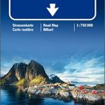
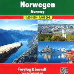
Norway Hallwag Road Map

Detailed and indexed touring map of Norway, dividing the country between north and south. The map shows seven different kind of roads plus footpaths, with road names and junction numbers, intermediate driving distances in km, petrol stations, restaurants and motels along main roads..Railways, cable cars, ferry lines and airports are also marked alongside national boundaries, mountain passes, toll roads, national parks and pick highs. A number of symbols also indicates places of interests, notable buildings and ruins, monuments, campsites and detached houses.The map also includes a special “Distoguide” incorporated into the map cover, showing at a glance road distances between several Scandinavian cities.All texts are in six different European languages including English.

Related Products:
 Finland Hallwag Road Map
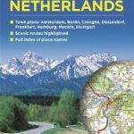
 Netherlands Hallwag Road Map
 Germany South Hallwag Road Map
 Denmark Hallwag Road Map
 USA Hallwag Road Map
 Canada Hallwag Road Map
 Canada East Hallwag Road Map
 Canada West Hallwag Road Map
 Europe Hallwag Road Map
 South Africa – Namibia – Botswana Hallwag Road Map
 Italy Hallwag Road Map
 Norway K+F Road Map
 Pacific Northwest USA 01 Hallwag Road Map
 Norway F&B Supertouring Road Atlas SPIRAL-BOUND
 Great Lakes USA 03 Hallwag Road Map
 Southwest – Southern Rockies USA 06 Hallwag Road Map
 Southern Norway North – Oslo – Bergen – Rondvassbu – Galdhopiggen Cappelen Sectional Road Map
 Switzerland Hallwag Touring Atlas
 California – Nevada USA 05 Hallwag Road Map
 Italy North Hallwag Road Map
 Norway Cappelens Road Atlas A4 SPIRAL-BOUND
 Southeast – Middle Atlantic USA 08 Hallwag Road Map
 Deep South USA 10 Hallwag Road Map
 Southern Norway South – Oslo – Stavanger – Bergen – Hardangervidda Cappelen Sectional Road Map
 Florida USA 11 Hallwag Road Map
 Switzerland Hallwag City Atlas
 Texas USA 09 Hallwag Road Map
 USA: Hallwag Regional Road Maps
 South Central USA 07 Hallwag Road Map
 North Central – Great Plains USA 02 Hallwag Road Map
 Norway: Freytag & Berndt Regional Road Maps
Norway: Cappelen Regional Road Maps
Norway: Freytag & Berndt Regional Road Maps
Norway: Cappelen Regional Road Maps
 New England – Atlantic Northeast USA 04 Hallwag Road Map
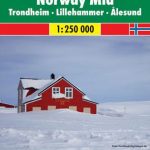
 Norway: Norstedts Regional Road Maps
 Spain and Portugal Philip`s Road Map
 Germany & Netherlands Philip`s Road Map
 Italy Philip`s Road Map
 South Africa Map Studio Road Atlas A4 PAPERBACK
 France & Belgium Philip`s Road Map
 France IGN Mini Road Map