Disclosure : This site contains affiliate links to products. We may receive a commission for purchases made through these links.
Northern Spain NGS Adventure Map 3306
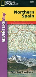
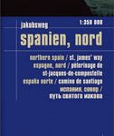
Northern Spain at 1:380,000 in a series of Adventure maps from the National Geographic Society with cartography provided by Reise Know-How. The map is double-sided and printed on light waterproof and tear-resistant plastic paper. Cartographic information provided by Reise Know-How has been adjusted to follow the house style of the NGS Adventure series with greater emphasis on the country’s topography. Altitude colouring in broader bands has been replaced here by contours at 200m intervals enhanced by relief shading. The main route of the Way of St James from Pamplona, across Logroรฑo, Burgos, Leรณn and Ponferrada is clearly marked. The map also shows the alterative coastal route and its variants. Various churches and monasteries along the route are highlighted.Road network includes local roads and tracks and gives driving distances on main and secondary roads. The map also shows railway lines and internal administrative boundaries with names of the provinces. Latitude and longitude grid is at intervals of 20’ and an extensive index of localities is provided. Overall, the NGS map presents a more vivid picture of the region’s topography, whilst the original RK-H version provides clearer information for touring by road or rail.PLEASE NOTE: to ensure regular supplies and faster delivery to our customers we keep this title in regular stock in its Reise Know-How edition. The NGS version can be ordered on request.

Related Products:
 Finland and Northern Scandinavia NGS Adventure Map 3300
 Spain – Portugal Adventure Map
 Tuscany Adventure Map
 Sicily NGS Adventure Map 3310
 Ecuador – Galapagos NGS Adventure Map 3403
 Australia Adventure Map
 Southern Sweden and Norway Adventure Map
 Nicaragua – Honduras – El Salvador NGS Adventure Map 3109
 China Adventure Map
 Peru NGS Adventure Map 3404
 Thailand Adventure Map
 Morocco NGS Adventure Map 3203
 Slovenia Adventure Map
 China East Adventure Map
 Mexico NGS Adventure Map 3108
 South Africa Adventure Map
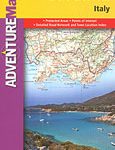
 Italy NGS Adventure Map 3304
 Sardinia NGS Adventure Map 3309
 Egypt NGS Adventure Map 3202
 Vietnam North NGS Adventure Map 3015
 Vietnam South NGS Adventure Map 3016
 New Zealand Adventure Map
 Australia East Adventure Map
 Chile NGS Adventure Map 3402
 Argentina NGS Adventure Map 3400
 Brazil NGS Adventure Map 3401
 India South Adventure Map
 India Adventure Map
 India Northeast NGS Adventure Map 3012
 Southern France Adventure Map
 Ireland Adventure Map
 Spain North – Santiago Route Reise Know-How
 Corsica Adventure Map
 Zimbabwe Map Studio Adventure Map
 Nepal Adventure Map
 Cuba NGS Adventure Map 3112
 Northern Yucatan Peninsula NGS Adventure Map 3105
 Northern Baja California NGS Adventure Map 3103
 Namibia Map Studio Adventure Map
 France Adventure Map