Disclosure : This site contains affiliate links to products. We may receive a commission for purchases made through these links.
North Polar Chart 1902 SMALL
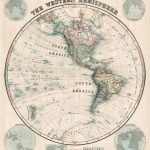
The Western Hemisphere in the third quarter of the 19th century on a cloth-backed reproduction of a map drawn by the Stanford’s Geographical Establishment and ‘published under the direction of the Committee of General Literature and Education Appointed by The Society for Promoting Christian Knowledge and of the National Society”.Individual countries are presented in gentle pastel hues typical of hand-coloured maps, with their borders outlined in stronger colours. The publication date of 1877 gives us the Americas more or less as we know them now but Antarctica with only a handful of coastal places named and believed to be flat as a pancake. Hachures are used to show the mountain ranges and many other features of contemporary cartography are included: ocean currents and trade winds, surrounding frames showing the tropical zones and the position of the sun, etc. Latitude and longitude lines are drawn at 10ยฐ intervals. Additional panels on this map of the Western Hemisphere give examples of six different map projections. Each individual map in this cloth-backed version is sold folded in a colourful case covered with a unique design marbled paper ‘“ no two cases are identical.PLEASE NOTE: a wall map version of this title is available as part of the ‘Stanfords Classics Collection of Historical Reproductions”. To see the full list of other titles in this series from the Old Folding Maps please click on the series link.

Related Products:
 North Polar Chart 1902 MEDIUM
 Western Hemisphere: Stanfords Map from 1877 SMALL
 Stanfords Western Hemisphere Wall Map c.1877 LARGE
 Stanford`s Western Hemisphere Map (1877) – A3 Wall Map, Paper
Stanford`s Western Hemisphere Map (1877) – A2 Wall Map, Paper
Stanford`s Western Hemisphere Map (1877) – A2 Wall Map, Canvas
Stanford`s Western Hemisphere Map (1877) – Original Size Wall Map, Paper
Stanford`s Western Hemisphere Map (1877) – Original Size Wall Map, Canvas
Stanford`s Western Hemisphere Map (1877) – A1 Wall Map, Paper – Print on Demand
Stanford`s Western Hemisphere Map (1877) – A1 Wall Map, Canvas
Stanford`s Western Hemisphere Map (1877) – A3 Wall Map, Paper
Stanford`s Western Hemisphere Map (1877) – A2 Wall Map, Paper
Stanford`s Western Hemisphere Map (1877) – A2 Wall Map, Canvas
Stanford`s Western Hemisphere Map (1877) – Original Size Wall Map, Paper
Stanford`s Western Hemisphere Map (1877) – Original Size Wall Map, Canvas
Stanford`s Western Hemisphere Map (1877) – A1 Wall Map, Paper – Print on Demand
Stanford`s Western Hemisphere Map (1877) – A1 Wall Map, Canvas
 Eastern Hemisphere: Stanfords Map from 1877 SMALL
 Stanford`s Eastern and Western Hemispheres Map (1877) – A3 Wall Map, Paper
Stanford`s Eastern and Western Hemispheres Map (1877) – A3 Wall Map, Canvas
Stanford`s Eastern and Western Hemispheres Map (1877) – A2 Wall Map, Paper
Stanford`s Eastern and Western Hemispheres Map (1877) – A2 Wall Map, Canvas
Stanford`s Eastern and Western Hemispheres Map (1877) – A1 Wall Map, Paper
Stanford`s Eastern and Western Hemispheres Map (1877) – A1 Wall Map, Canvas
Stanford`s Eastern and Western Hemispheres Map (1877) – Original Size Wall Map, Paper
Stanford`s Eastern and Western Hemispheres Map (1877) – Original Size Wall Map, Canvas
Stanford`s Eastern and Western Hemispheres Map (1877) – A3 Wall Map, Paper
Stanford`s Eastern and Western Hemispheres Map (1877) – A3 Wall Map, Canvas
Stanford`s Eastern and Western Hemispheres Map (1877) – A2 Wall Map, Paper
Stanford`s Eastern and Western Hemispheres Map (1877) – A2 Wall Map, Canvas
Stanford`s Eastern and Western Hemispheres Map (1877) – A1 Wall Map, Paper
Stanford`s Eastern and Western Hemispheres Map (1877) – A1 Wall Map, Canvas
Stanford`s Eastern and Western Hemispheres Map (1877) – Original Size Wall Map, Paper
Stanford`s Eastern and Western Hemispheres Map (1877) – Original Size Wall Map, Canvas
 Stanford`s Eastern Hemisphere Map (1877) – A3 Wall Map, Paper
Stanford`s Eastern Hemisphere Map (1877) – A3 Wall Map, Canvas
Stanford`s Eastern Hemisphere Map (1877) – A2 Wall Map, Paper
Stanford`s Eastern Hemisphere Map (1877) – A2 Wall Map, Canvas
Stanford`s Eastern Hemisphere Map (1877) – A1 Wall Map, Canvas
Stanford`s Eastern Hemisphere Map (1877) – Original Size Wall Map, Paper
Stanford`s Eastern Hemisphere Map (1877) – Original Size Wall Map, Canvas
Stanford`s Eastern Hemisphere Map (1877) – A1 Wall Map, Paper – Print on Demand
Stanford`s Eastern Hemisphere Map (1877) – A3 Wall Map, Paper
Stanford`s Eastern Hemisphere Map (1877) – A3 Wall Map, Canvas
Stanford`s Eastern Hemisphere Map (1877) – A2 Wall Map, Paper
Stanford`s Eastern Hemisphere Map (1877) – A2 Wall Map, Canvas
Stanford`s Eastern Hemisphere Map (1877) – A1 Wall Map, Canvas
Stanford`s Eastern Hemisphere Map (1877) – Original Size Wall Map, Paper
Stanford`s Eastern Hemisphere Map (1877) – Original Size Wall Map, Canvas
Stanford`s Eastern Hemisphere Map (1877) – A1 Wall Map, Paper – Print on Demand
 Stanford`s Pacific-centred World Map (1884) – Original Size Wall Map, Paper
Stanford`s Pacific-centred World Map (1884) – Original Size Wall Map, Canvas
Stanford`s Pacific-centred World Map (1884) – Original Size Wall Map, Paper
Stanford`s Pacific-centred World Map (1884) – Original Size Wall Map, Canvas
 World: Stanfords Pacific Centred Map of the World 1884 SMALL
 Australian Colonies and New Zealand c.1874 SMALL
Australian Colonies and New Zealand c.1874 MEDIUM
London: Rocque London c. 1741-5 MEDIUM
Paris: Plan de Paris c.1818 SMALL
Paris: Plan de Paris c.1818 MEDIUM
Australian Colonies and New Zealand c.1874 SMALL
Australian Colonies and New Zealand c.1874 MEDIUM
London: Rocque London c. 1741-5 MEDIUM
Paris: Plan de Paris c.1818 SMALL
Paris: Plan de Paris c.1818 MEDIUM
 Africa: Gall & Inglis Map c.1854 SMALL
Africa: Gall & Inglis Map c.1854 MEDIUM
Africa: Gall & Inglis Map c.1854 SMALL
Africa: Gall & Inglis Map c.1854 MEDIUM
 Palestine or the Holy Land c.1818 MEDIUM
Palestine or the Holy Land c.1818 SMALL
Palestine or the Holy Land c.1818 MEDIUM
Palestine or the Holy Land c.1818 SMALL
 Paris: Plan de Paris et ses Fortifications c.1844 MEDIUM