Disclosure : This site contains affiliate links to products. We may receive a commission for purchases made through these links.
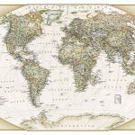
NGS Executive Political World Wall Map 3-SHEET SET, ENCAPSULATED

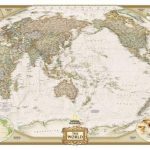
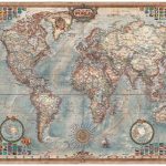
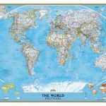
Encapsulated version of the extra large, 296 x 193cm (9ft 8″ x 6ft 4″) political map of the world in the NGS Executive series which offers current information presented in elegant antique style. Countries are in rich but muted colours and oceans in beige, with additional panels and framing in shades of brown.An unusual feature of this series is the excellent presentation of the ocean floor, with impressive relief shading to show the continental shelf around the land masses and numerous ridges, many with names. Unfortunately, although clear and very effective on all the sizes of this design, the samples presented here cannot do full justice to such fine detail.On land, the map has relief shading with names of main mountain ranges. Heights for peaks are given in feet. Within USA boundaries and names of states are shown. Four insets present the Arctic and the Antarctic, plus vegetation/land use and population density world maps. Also provided are lists of 10 largest countries by area and by populations. Projection is Winkel Tripel, which reduces distortion of land masses as they near the poles.PLEASE NOTE: Because of the overall size of this map it is not possible to encapsulate it with the three sheets already joined. Like the paper set, the encapsulated version also comes in three separate sheets, but is already fitted with special tape, ready for the map to be easily joined together. The map can be assembled only Atlantic centred.NGS Executive Style World Maps are published in three sizes: standard (116.5 x 77.5cm / 46″ x 30″ approx), enlarged (185 x 122cm / 73″ x 48″ approx) and a 3-sheet set (296 x 193cm / 9ft 8″ x 6ft 4″ approx) – TO SEE ALL THE OPTIONS PLEASE CLICK ON THE SERIES LINK.LAMINATED and ENCAPSULATED WALL MAPS:- LAMINATED wall maps have a thin layer of plastic usually applied to the printed side only. They can be written on with suitable marker pens without any damage to the map but, unless they have been laminated on both sides, they are not damp-proof.- ENCAPSULATED wall maps are sealed between two sheets of plastic. They are more rigid and heavier than laminated maps of the same size. They are damp-proof and do not crinkle in humid conditions. Encapsulation gives the map a shiny surface, similar to being displayed behind glass.- PLEASE NOTE: many publishers and retailers often use these two terms interchangeably. Our map titles and descriptions follow the definitions provided above.- as this map is encapsulated, it is *not suitable for use with wallpaper paste*.

Related Products:
 World NGS Executive Wall Map ENCAPSULATED
 World NGS Executive Pacific-Centered Wall Map ENCAPSULATED
 World NGS Executive Wall Map LARGE ENCAPSULATED
 World NGS Executive Pacific-Centered Wall Map LARGE ENCAPSULATED
 World Executive Ray & Co Wall Map ENCAPSULATED
 South America NGS Executive Wall Map ENCAPSULATED
 World Global Mapping Political Wall Map LARGE ENCAPSULATED
 Italy NGS Executive Wall Map ENCAPSULATED
World Global Mapping Political Wall Map MEDIUM ENCAPSULATED
Italy NGS Executive Wall Map ENCAPSULATED
World Global Mapping Political Wall Map MEDIUM ENCAPSULATED
 World NGS Classic Wall Map 3-SHEET SET ENCAPSULATED
 Spain and Portugal NGS Executive Wall Map ENCAPSULATED
Scotland NGS Executive Wall Map ENCAPSULATED
Spain and Portugal NGS Executive Wall Map ENCAPSULATED
Scotland NGS Executive Wall Map ENCAPSULATED
 Ireland NGS Executive Wall Map ENCAPSULATED
 World Global Mapping Political Wall Map X-LARGE ENCAPSULATED
 World NGS Executive Mural Wall Map 3-SHEET SET PAPER
 France, Belgium and Netherlands NGS Executive Wall Map ENCAPSULATED
 Japan NGS Executive Wall Map ENCAPSULATED
 Germany NGS Executive Wall Map ENCAPSULATED
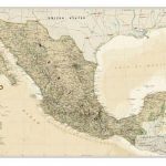 Mexico NGS Executive Wall Map ENCAPSULATED
 World NGS Explorer Executive Wall Map ENCAPSULATED
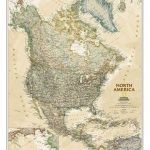 North America NGS Executive Wall Map ENCAPSULATED
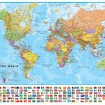
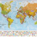 World Maps International Political Wall Map SMALL ENCAPSULATED
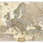 Europe NGS Executive Wall Map ENCAPSULATED
 China NGS Executive Wall Map ENCAPSULATED
NGS Executive Political World Wall Map FRAMED
China NGS Executive Wall Map ENCAPSULATED
NGS Executive Political World Wall Map FRAMED
 World Maps International Political Upside-down Wall Map LARGE ENCAPSULATED
 Australia NGS Executive Wall Map ENCAPSULATED
 England and Wales NGS Executive Wall Map ENCAPSULATED
 Brazil NGS Executive Wall Map ENCAPSULATED
 Britain and Ireland NGS Executive Wall Map ENCAPSULATED
 NGS Executive Political World Wall Map ENLARGED, FRAMED
 Future Mapping Company Monochrome Political World Wall Map ENCAPSULATED
 Asia NGS Executive Wall Map ENCAPSULATED
 World Maps International Political Wall Map LARGE ENCAPSULATED
 United States NGS Executive Wall Map ENCAPSULATED
 World Hemispheres NGS Wall Map ENCAPSULATED
 World: National Geographic Society Executive Style Political Wall Maps
 World Rand McNally Classic Wall Map ENCAPSULATED
 World Rand McNally Signature Wall Map ENCAPSULATED
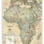 Africa NGS Executive Wall Map ENCAPSULATED