Disclosure : This site contains affiliate links to products. We may receive a commission for purchases made through these links.
Newquay East 1933
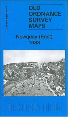
Newquay East in 1933 in a fascinating series of reproductions of old Ordnance Survey plans in the Alan Godfrey Editions, ideal for anyone interested in the history of their neighbourhood or family. The map covers the eastern part of the town, extending from Tolcarne Point and the station eastward to part of Treviglass. Features include railway with station and engine shed, Tolcarne Sands, Barrowfields, Lusty Glaze, Trenance, Narrow Cliff, Porth Veor, isolation hospital, Tretherras, Gusti Veor etc. Extracts from a 1910 directory are on the reverse. About the Alan Godfrey Editions of the 25″ OS SeriesSelected towns in Great Britain and Ireland are covered by maps showing the extent of urban development in the last decades of the 19th and early 20th century. The plans have been taken from the Ordnance Survey mapping and reprinted at about 15 inches to one mile (1:4,340). On the reverse most maps have historical notes and many also include extracts from contemporary directories. Most maps cover about one mile (1.6kms) north/south, one and a half miles (2.4kms) across; adjoining sheets can be combined to provide wider coverage.FOR MORE INFORMATION AND A COMPLETE LIST OF ALL AVAILABLE TITLES PLEASE CLICK ON THE SERIES LINK.

Related Products:
 Newquay West 1933
 Glasgow High Street 1933
 East Boldon 1895
St Austell 1933
East Boldon 1895
St Austell 1933
 Croydon East: Coombe Park & Addiscombe Road 1895 – 158
Glasgow East End 1893
Croydon East: Coombe Park & Addiscombe Road 1895 – 158
Glasgow East End 1893
 East Finchley 1894 – 10.2
Craigendoran and Helensburgh East 1897
Durham City East 1894
Colwyn Bay South East 1911
Glasgow St Rollox 1933
East Ham & Barking 1915 – 44.3
East Finchley 1894 – 10.2
Craigendoran and Helensburgh East 1897
Durham City East 1894
Colwyn Bay South East 1911
Glasgow St Rollox 1933
East Ham & Barking 1915 – 44.3
 Stockport East 1897
Halesowen (East) 1913 – 5.13b
East Jarrow 1913
Maldon (East) 1920 – 56.13
Stockport East 1897
Halesowen (East) 1913 – 5.13b
East Jarrow 1913
Maldon (East) 1920 – 56.13
 Whitstable East 1906
 Bromley Common and North-East Hayes 1895
Hampton Court & East Molesey 1912 – 12.13
Rutherglen East 1910
Manchester South-East 1915
Gateshead East 1895
Hetton-le-Hole and East Rainton 1895
Motherwell (East) 1897 – 12.14
Willenhall North East 1885
Bromley Common and North-East Hayes 1895
Hampton Court & East Molesey 1912 – 12.13
Rutherglen East 1910
Manchester South-East 1915
Gateshead East 1895
Hetton-le-Hole and East Rainton 1895
Motherwell (East) 1897 – 12.14
Willenhall North East 1885
 East Bierley 1905
Crook East 1896
Cirencester East 1920
Bulwell 1913 – 38.05
Dun Laoghaire 1908
East Tanfield and Causey Arch 1895
East Bierley 1905
Crook East 1896
Cirencester East 1920
Bulwell 1913 – 38.05
Dun Laoghaire 1908
East Tanfield and Causey Arch 1895
 Plumstead 1867
Honiton 1903
Plumstead 1867
Honiton 1903
 Croydon North-East 1895
Shotts (West) 1939 – 13.06
East Finchley & Hampstead Garden Suburb 1894-1911 – 10.3
Redditch East 1903
Croydon North-East 1895
Shotts (West) 1939 – 13.06
East Finchley & Hampstead Garden Suburb 1894-1911 – 10.3
Redditch East 1903
 Aberystwyth 1904
Hull (East) 1908 – 240.03b
Aberystwyth 1904
Hull (East) 1908 – 240.03b
 Mid Finchley 1934