Disclosure : This site contains affiliate links to products. We may receive a commission for purchases made through these links.
New Quay 1904
New Quay in 1904 in a fascinating series of reproductions of old Ordnance Survey plans in the Alan Godfrey Editions, ideal for anyone interested in the history of their neighbourhood or family. Features include the harbour, New Quay Head, St Llwchaiarn`s church, Towyn Chapel, and many outlying houses. Coverage extends a mile west to the coast of Craig Grogal. A 1906 directory of the town is on the reverse.About the Alan Godfrey Editions of the 25″ OS Series:Selected towns in Great Britain and Ireland are covered by maps showing the extent of urban development in the last decades of the 19th and early 20th century. The plans have been taken from the Ordnance Survey mapping and reprinted at about 15 inches to one mile (1:4,340). On the reverse most maps have historical notes and many also include extracts from contemporary directories. Most maps cover about one mile (1.6kms) north/south, one and a half miles (2.4kms) across; adjoining sheets can be combined to provide wider coverage.FOR MORE INFORMATION AND A COMPLETE LIST OF ALL AVAILABLE TITLES PLEASE CLICK ON THE SERIES LINK.

Related Products:
 Willington Quay 1895
St Anthonys and Bill Quay 1912
Willington Quay 1895
St Anthonys and Bill Quay 1912
 Aberaeron 1904
Lampeter 1904
Aberaeron 1904
Lampeter 1904
 King`s Lynn 1904 – 33.10
Monk Bretton & Smithies 1904 – 274.04
King`s Lynn 1904 – 33.10
Monk Bretton & Smithies 1904 – 274.04
 Aberystwyth 1904
 Cudworth 1904
Barnsley South 1904
Marsden 1904
Royston 1904
Cudworth 1904
Barnsley South 1904
Marsden 1904
Royston 1904
 Woolton 1904
Barnsley 1904
Boothstown and Astley Green 1904
Flixton 1904
Torquay 1904
Gateacre 1904
Paignton 1904
Bideford 1904 – 19.06
Newhaven & Granton 1904 – 1.15
Fallowfield 1904
Dun Laoghaire 1908
Llandovery 1904 – 18.13
Holmfirth 1904
Woolton 1904
Barnsley 1904
Boothstown and Astley Green 1904
Flixton 1904
Torquay 1904
Gateacre 1904
Paignton 1904
Bideford 1904 – 19.06
Newhaven & Granton 1904 – 1.15
Fallowfield 1904
Dun Laoghaire 1908
Llandovery 1904 – 18.13
Holmfirth 1904
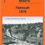 Falmouth 1878
Barnsley North East 1904
Falmouth 1878
Barnsley North East 1904
 Reeth and Grinton 1910
 Tipton 1904
Campbeltown 1898 – 257.08
Wadebridge 1906
Tipton 1904
Campbeltown 1898 – 257.08
Wadebridge 1906
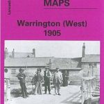 Warrington West 1905
 Llangollen 1910
Warley 1902
Honiton 1903
Foulness and Mersea 1904
Llangollen 1910
Warley 1902
Honiton 1903
Foulness and Mersea 1904
 Great Britain: Godfrey Editions of Historical Ordnance Survey “A Yard to the Mile” City Plans
Wivenhoe 1896
Great Britain: Godfrey Editions of Historical Ordnance Survey “A Yard to the Mile” City Plans
Wivenhoe 1896
 Tong 1905
Central Glasgow 1934 – 6.10c
Central Glasgow 1893 – 6.10a
Tong 1905
Central Glasgow 1934 – 6.10c
Central Glasgow 1893 – 6.10a