Disclosure : This site contains affiliate links to products. We may receive a commission for purchases made through these links.
New Brunswick – Prince Edward Island FastTrack
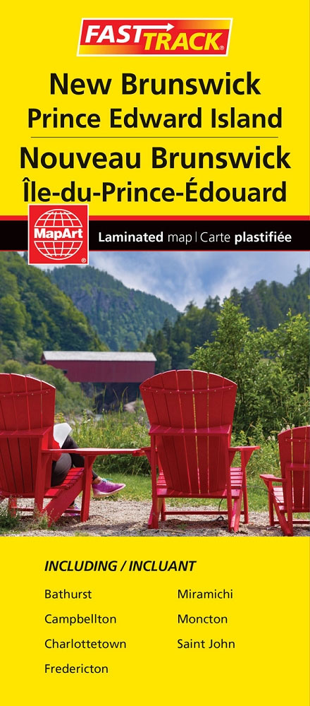
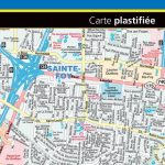
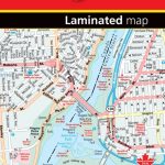
Waterproof and tear-resistant FastTrack map presenting in a handy-size format indexed road maps of New Brunswick and Price Edward Island, both at 1:667,000, plus enlargements showing main urban areas in greater detail.New Brunswick is covered on two overlapping panels, with Prince Edward Island presented separately. The maps show road network indicating unpaved roads and give driving distances on main routes. National parks and protected areas are prominently highlighted and symbols indicate campsites, visitor information centres, historic sites, etc. The maps have no geographical coordinates. Enlargements present in greater detail Saint John (1:125,000) plus Bathhurst, Fredericton, Campbelton, Charlottetown, Moncton and Miramichi (all at 1:100,000). A separate panel at 1:667,000 covers the nearby Iles-de-la-Madeleine. Also provided is a list of the regional ferry operators.To see the list of currently available Canadian province and regional maps form the MapArt / Canadian Cartographics Corporation / JDM Gรฉo publishing group, including waterproof and tear-resistant FastTrack titles, please click on the series link.

Related Products:
 Atlantic Canada – New Brunswick – Nova Scotia – Prince Edward Island – Newfoundland
 Moon Nova Scotia, New Brunswick & Prince Edward Island
 Vancouver Island FastTrack
 Prince Edward Island
 New Brunswick MapArt
 Lonely Planet Nova Scotia, New Brunswick & Prince Edward Island
 Maritimes Provinces: New Brunswick – Nova Scotia – Prince Edward Island MapArt Back Road Atlas
 Moon Atlantic Canada (Ninth Edition): Nova Scotia, New Brunswick, Prince Edward Island, Newfoundland & Labrador
 Moon Atlantic Canada (Tenth Edition): Nova Scotia, New Brunswick, Prince Edward Island, Newfoundland & Labrador
 British Columbia FastTrack
 Fodor`s Nova Scotia & Atlantic Canada: With New Brunswick, Prince Edward Island, and Newfoundland
 Edmonton – Jasper & Environs FastTrack
 Vancouver Island NGS Adventuer Map 3128
 Prince Edward Island ITMB
 Frommer`s EasyGuide to Prince Edward Island, Nova Scotia and New Brunswick
 Ontario Northern FastTrack Map: North Bay – Sudbury – Thunder Bay – Lake of the Woods
 Newfoundland & Labrador FastTrack
 Quรฉbec Province FastTrack
 Quebec City FastTrack
 Nova Scotia & Prince Edward Island ITMB
Montreal FastTrack
Nova Scotia & Prince Edward Island ITMB
Montreal FastTrack
 Alberta FastTrack
 Edmonton – Sherwood Park FastTrack Map
 Saskatchewan FastTrack
 Victoria FastTrack
 Nova Scotia and Prince Edward Island inc Iles de la Madeleine & Sable Island
 British Columbia – Alberta FastTrack
 Niagara Region (Canada) FastTrack Map
 Calgary – Banff & Enviros FastTrack
 Vancouver FastTrack
 Ottawa – Gatineau FastTrack
 Nova Scotia MapArt
Vancouver Island – Sunshine Coast – Gulf Islands BC MapArt
Nova Scotia MapArt
Vancouver Island – Sunshine Coast – Gulf Islands BC MapArt
 Canada FastTrack
CHS Chart 4925 – Harbours on the North Shore of Prince Edward Island
Canada FastTrack
CHS Chart 4925 – Harbours on the North Shore of Prince Edward Island
 Winnipeg FastTrack
 Cape Breton Island – Sydney – Truro NS MapArt
 SHOM Chart 7604 – De Prince Edward Islands ร Heard Island – Iles Crozet , Kerguelen et Amsterdam
 Punta Arenas – Peninsula de Brunswick SIG Patagon
Ontario MapArt
Punta Arenas – Peninsula de Brunswick SIG Patagon
Ontario MapArt