Disclosure : This site contains affiliate links to products. We may receive a commission for purchases made through these links.
Netherlands: Falk Recreational Maps
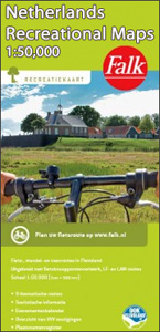
These maps were created to celebrate the 25th anniversary of the province of Flevoland. They are double-sided indexed maps at 1:50,000 scale, featuring a detailed topography with prominent highlighting of the cycle routes and packed with practical tourist information. They also include a calendar of annual events and feature all the local hiking trails.Falk maps give cycling distances between the junctions and indicate which roads, both within the numbered network and outside it, have separate cycling paths. Routes which are part of the LF network of long-distance cycle routes are clearly marked. A wide range of symbols shows various accommodation options, bars and restaurants, and various places of interest. Landscape information is provided by colouring for woodlands, dunes, etc. Map legend includes English.The maps are produced in collaboration with the Province of Flevoland, the Flevoland Tourist Foundation, and the National Cycle Network.

Related Products:
 Netherland & Flanders: Falk 50K Cycling Maps
 Netherlands: Falk/VVV Hiking Maps
 Netherlands: ANWB 50K Cycling Maps
 The IJssel
 Netherlands Falkplan Cycling Atlas
Flevoland – Kop van Overijssel Falkplan Cycling Map 06
Netherlands Falkplan Cycling Atlas
Flevoland – Kop van Overijssel Falkplan Cycling Map 06
 Netherlands: Falk Maps of the Conservation Areas
 France: Kummerly + Frey Recreational Maps of the Vosges Mountains and Alsace
Antwerp Kempen Falkplan Cycling Map 32
France: Kummerly + Frey Recreational Maps of the Vosges Mountains and Alsace
Antwerp Kempen Falkplan Cycling Map 32
 Lithuania: Briedis 50K Recreational Maps
 Zeelandic Flanders – Meetjesland and Waasland Falkplan Cycling Map 31
Flemish Brabant Falkplan Cycling Map 36
Zeelandic Flanders – Meetjesland and Waasland Falkplan Cycling Map 31
Flemish Brabant Falkplan Cycling Map 36
 Belgian Limburg Cycling Map
Groningen – Lauwersmeer Falkplan Cycling Map
Belgian Limburg Cycling Map
Groningen – Lauwersmeer Falkplan Cycling Map
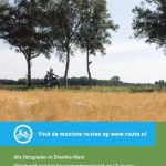 Drenthe West Cycling Map
 Drenthe East Cycling Map
 North Holland – with Kennemerland Falkplan Cycling Map 13
 Ardennes Falkplan Cycling Map 37
 France: IGN 75K/25K TOP75 Recreational Maps
Brabant West and Central Cycling Map
France: IGN 75K/25K TOP75 Recreational Maps
Brabant West and Central Cycling Map
 Zeeland Islands with Zeelandic Flanders Falkplan Cycling Map 16
Limburg Central and South Falkplan Cycling Map 20
North Limburg – De Pell and De Maasduinen Falkplan Cycling Map 19
Drenthe East – Southeast Groningen Falkplan Cycling Map
South-Holland South – Goeree-Overflakkee Falkplan Cycling Map 15
Westhoek – South-West Flanders Falkplan Cycling Map 34
South-Holland North – Green Heart West and Bollenstreek Falkplan Cycling Map 14
Zeeland Islands with Zeelandic Flanders Falkplan Cycling Map 16
Limburg Central and South Falkplan Cycling Map 20
North Limburg – De Pell and De Maasduinen Falkplan Cycling Map 19
Drenthe East – Southeast Groningen Falkplan Cycling Map
South-Holland South – Goeree-Overflakkee Falkplan Cycling Map 15
Westhoek – South-West Flanders Falkplan Cycling Map 34
South-Holland North – Green Heart West and Bollenstreek Falkplan Cycling Map 14
 Belgian Coast Cycling Map 30
 Veluwe Falkplan Cycling Map 09
 Twente Falkplan Cycling Map 08
Achterhoek Falkplan Cycling Map 10
Twente Falkplan Cycling Map 08
Achterhoek Falkplan Cycling Map 10
 Vechtdal and Salland Cycling Map
Kempenland – de Meijerij Falkplan Cycling Map 18
Vechtdal and Salland Falkplan Cycling Map 07
Vechtdal and Salland Cycling Map
Kempenland – de Meijerij Falkplan Cycling Map 18
Vechtdal and Salland Falkplan Cycling Map 07
 Friese Meren – South Friesland Falkplan Cycling Map 03
 West Frisian Islands Falkplan Cycling Map
 Germany: Rhineland-Palatinate 50K Topographic Survey Recreational Maps
Rivierenland – De Biesbosch – Rijk van Nijmegen Falkplan Cycling Map 11
Germany: Rhineland-Palatinate 50K Topographic Survey Recreational Maps
Rivierenland – De Biesbosch – Rijk van Nijmegen Falkplan Cycling Map 11
 Austria: Kรผmmerly+Frey Recreational Maps
Utrecht Hills – `t Gooi – Vecht area Falkplan Cycling Map 12
Austria: Kรผmmerly+Frey Recreational Maps
Utrecht Hills – `t Gooi – Vecht area Falkplan Cycling Map 12