Disclosure : This site contains affiliate links to products. We may receive a commission for purchases made through these links.
Munich F&B
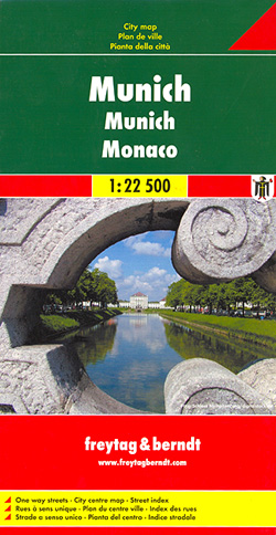
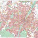
Large street plan of Munich within its administrative boundaries, with an enlargement of the city centre, a plan of its airport, a diagram of the U and S-Bahn networks and a map of the outer suburbs all conveniently placed in a separate booklet. The main plan covers Munich at 1:22,500, showing the city’s public transport network: tram and bus routes with stops and line numbers, plus U- and S-Bahn stations. Campsites and youth hostels are marked, as well as the usual range of facilities shown on street plans; public buildings, religious establishments, police, etc.Map legend which includes English is in a separate booklet attached to the map cover. The booklet also contains a very clear enlargement at 1:10,000 of the town centre within the inner ring, indicating one way streets and public transport connection, a diagram of the U- and S-Bahn networks and an overview map of the city with its outer suburbs.

Related Products:
 Munich F&B Wall Map
 Munich F&B Wall Map – with Metal Hanging Strips
 Munich Marco Polo City Map
 Munich Falk Cityplan
 Berlin Michelin City Map
 Munich in 3-D Street Plan
 Munich & Bavaria ITMB
Munich EXTRA
Munich & Bavaria ITMB
Munich EXTRA
 Nuremberg City Pocket Plan
Nuremberg Falk EXTRA Street Plan
Nuremberg City Pocket Plan
Nuremberg Falk EXTRA Street Plan
 Frankfurt am Main Borch
 Munich Borch
 Berlin Cityplan Pocket Map
 Linz F&B Tourist Street Plan
 Budapest F&B
 Moscow Jana Seta Street Plan
 Munich – Augsburg – Erding – Ingolstadt – Landshut ADAC Street Atlas
 Ljubljana
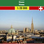 Vienna F&B
 Maribor
 Australia: UBD Gregory`s Street Maps and Directories
 Brussels Hike & Bike Map
 Greater Brussels Hike & Bike Map
 Lille and Surroundings Blay-Foldex Street Atlas
 Halle Forest Hike & Bike Map
 Christchurch Visitors` Street Plan
 Florence Marco Polo City Map
 Riga and Vicinity Jana Seta Street Atlas
 Amsterdam Michelin City Map
 Cape Town Marco Polo City Map
 Valencia Michelin City Map
Point It – Oktoberfest Language Kit – Graf`s picture dictionary for Munich & Oktoberfest
Valencia Michelin City Map
Point It – Oktoberfest Language Kit – Graf`s picture dictionary for Munich & Oktoberfest
 Tallinn Jana Seta Street Plan WATERPROOF
 Budapest Classic Plan
 Budapest Comfort Plan
 Kiel City Pocket Plan
 Munster City Pocket Plan
 Potsdam City Pocket Plan
 Bremen City Pocket Plan
 Dortmund City Pocket Plan