Disclosure : This site contains affiliate links to products. We may receive a commission for purchases made through these links.
Mount Everest 50th Anniversary NGS Wall Map
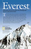
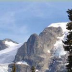
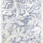
Mount Everest on a double-sided wall map from the National Geographic, produced to celebrate the 50th anniversary of the first ascent, combining on one side a spectacular panorama model highlighting three historical expedition routes, plus on the reverse a map of the Sagarmatha National Park, aerial views of the peak, etc.On one side is a spectacular photo-like panorama of the Everest area produced from digital data: 5m contour lines and aerial stereo-photographs combined to provide a three dimensional model. Coverage extends south-west to the 1953 and the present day Base Camps; from the peak of Mt Everest the map stretches beyond the North Col and Changtse, and on the other side Lhotse and Nuptse are included. Contour lines are drawn at 100m intervals; heights for peaks and passes are both in meters and feet. An overprint shows the routes of the British 1953 expedition when Sir Edmund Hillary and Tenzing Norgay first reaches the summit, of the 1963 US expedition when James Whittacker become the first American to climb Mt. Everest, and of the Chinese expedition which in 1960 became the first to reach the summit from the north side.On the reverse side is a map of the Sagarmatha National Park at 1:90,000 with finely drawn relief shading and colouring providing an excellent representation of the mountainous terrain. Coverage extends south to Lukla and the map shows settlements and various places of interest as well as trekking routes to the Everest Base Camp, Gokyo Lakes, the Island Peak and the Nangpa Glacier and Pass. Surrounding panels and text provide more information: aerial photos of the southern and the northern approaches overprinted with various expedition routes, a map showing the increase in the number of visitors to the area, notes and drawings about the Tibetan borderlands and sherpas homeland, etc.

Related Products:
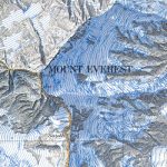
 National Geographic Mount Everest 50th Anniversary Side 1 805 X 526 mm
 Mount Everest
 Mount Qomolangma (Sagarmatha/Mount Everest)
 Everest Region Trekking Map
 Everest 1953: The Epic Story of the First Ascent
 The Ascent of Everest
 National Geographic Mount Everest – Published 1988 575 x 909 mm
 Tibet – Mount Everest – Nam Tso – Lhasa – Shigatse terraQuest Tourist Map
 Everest: The West Ridge
 Mount Everest Notebook
 Tenzing-Hillary Trek – Jiri to Everest Base Camp
 Everest & Himalaya ITMB
 The Hunt for Mount Everest
 Everest: Jiri to Everest Base Camp
 The Fight for Everest 1924: Mallory, Irvine and the Quest for Everest
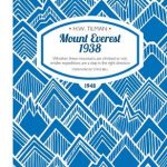 Mount Everest 1938: Whether These Mountains are Climbed or Not, Smaller Expeditions are a Step in the Right Direction
 Nine Lives: Expeditions to Everest
 The World – The National Geographic 125th Anniversary Wall Map ENCAPSULATED
 Everest Revealed: The Private Diaries and Sketches of Edward Norton, 1922-24
 Apollo 11 Landing – the Moon: 50th Anniversary Edition Wall Map
 Coronation Everest
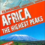 Africa`s Highest Peaks – Kilimanjaro – Mount Kenya – Rwenzori terraQuest Trekking Map
 Mount Xixabangma
 Mount Athos
 Everest: A Trekker`s Guide: Base Camp, Kala Patthar and other trekking routes in Nepal and Tibet
 Everest – Gokyo – Cho La – the Renjo Pass (60K)
 China South Wall Map
 Everest Base Camp & Gokyo – Three Passes 50K
 Everest – Trekking Map & Complete Guide
 Eyre Peninsula, SA
 The Third Pole: My Everest climb to find the truth about Mallory and Irvine
 Another Peak: Everest is Not the Only Summit
 The World – The National Geographic 125th Anniversary Wall Map PAPER
 Trekking in the Everest Region: Includes Kathmandu City Guide
 China North-East Wall Map
 Everest Base Camp NGS Adventure Map 3001
 Slovakia
 North America Columbus double-sided Political / Physical Wall Map
 Mount Kenya Map & Guide