Disclosure : This site contains affiliate links to products. We may receive a commission for purchases made through these links.
Mount Elgon
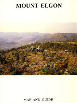
Three maps plus information for climbers. A detailed map at 1:50,000 with contours at 50m intervals shows the caldera itself and the surrounding peaks, with tracks and possible routes, caves, and a UTM grid. A more general map at 1:125,000, also contoured with intervals of 100m, shows the approaches to the mountain from the Kenyan side (including the organized campsites south of Masara), with latitude/longitude coordinates. A road map at 1:500,000 shows road links to towns and villages on both sides of the border, in Kenya and Uganda. On the reverse there is a useful section of information for anyone planning to climb the peak (e.g. equipment to take, weather conditions, hiring guides, etc).

Related Products:
 Mount Kenya Map & Guide
 Africa`s Highest Peaks – Kilimanjaro – Mount Kenya – Rwenzori terraQuest Trekking Map
 Turkey`s Highest Peaks – Mount Ararat – Kackar Mountains – Mount Suphan terraQuest Trekking Map
 Kenya – Tanzania – Uganda F&B
 Wildlife Of Kenya, Tanzania and Uganda
 Mount Etna Morphotectonic Map
 Bulgaria Reise Know-How
 Belarus Jana Seta Road Map
 Mount Athos
 Mount Everest
 Africa East & Central ITMB
 Rwenzori Mountains
 Ukraine – Belorussia – Moldova
 Lithuania Jana Seta Road Atlas HARDBACK
 Mount Kenya National Park Alpenverein 0/16
 Russia West Reise Know-How
 Kenya ITMB
 Mount Olympos Region – Eastern Lycia
 Uganda ITMB
 Kenya – Serengeti Nelles
 Eastern Rhodopes / Rodopi Geopsis 131
 Drakensberg and the Eastern Free State
 US / Mexico Border ITMB
 Mount Pelion – Mount Mavrovouni Anavasi 4.3/4.4
 Latvia Jana Seta Road Atlas
 Africa Equatorial ITMB
 Appalachian Trail: Hanover to Mount Carlo Hiking Atlas, NH/ME
 No Picnic on Mount Kenya
 Banff & Mount Assiniboine Gem Trek
 Appalachian Trail: Mount Carlo to Pleasant Pond Hiking Atlas, ME
Uganda Reise Know-How
Appalachian Trail: Mount Carlo to Pleasant Pond Hiking Atlas, ME
Uganda Reise Know-How
 Malaysia Odyssey Map
 Mount St Helens – Mount Adams – Gifford-Pinchot National Forest WA
 Japan Reise Know-How
 Cyprus Marco Polo Holiday Map
 Argentina South & Tierra del Fuego ITMB
 Vietnam, Laos & Cambodia ITMB
 Patagonia & Tierra del Fuego ITMB
 Central Rhodopes / Rodopi Geopsis 132