Disclosure : This site contains affiliate links to products. We may receive a commission for purchases made through these links.
Mossley Hill 1905
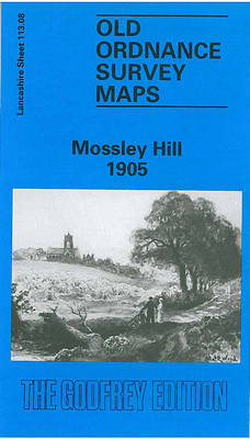
Mossley Hill in 1905 in a fascinating series of reproductions of old Ordnance Survey plans in the Alan Godfrey Editions, ideal for anyone interested in the history of their neighbourhood or family. The map covers much of the Mossley Hill area south-eastern Liverpool, including portions of Aigburth, Garston and Allerton. Coverage stretches from St Anne`s Road eastward to Allerton Road, and from Palmerston Road southward to Aigburth Hall Road. Features include Holmfield, Garston Old Vicarage, LNWR railway with Mossley Hill station, St Anne`s Crescent, Carnatic Hall, Elmwood Hall Laundry, streets being developed around station, Forty Pits, West Farm, Maryton Grange, Drygrange, etc; east of the railway the land is largely rural with some villas around Allerton Road. On the reverse are street directory entries for Allerton Road, Elmswood Road, Greenhill Road and Mossley Hill Road. About the Alan Godfrey Editions of the 25″ OS Series:Selected towns in Great Britain and Ireland are covered by maps showing the extent of urban development in the last decades of the 19th and early 20th century. The plans have been taken from the Ordnance Survey mapping and reprinted at about 15 inches to one mile (1:4,340). On the reverse most maps have historical notes and many also include extracts from contemporary directories. Most maps cover about one mile (1.6kms) north/south, one and a half miles (2.4kms) across; adjoining sheets can be combined to provide wider coverage.FOR MORE INFORMATION AND A COMPLETE LIST OF ALL AVAILABLE TITLES PLEASE CLICK ON THE SERIES LINK.

Related Products:
 Garston 1905 – 113.12b
 Allerton 1905
 Liverpool Edge Hill 1905
 Streatham Hill & Tulse Hill 1914 – 126.3
 Streatham Hill & Tulse Hill 1894 – 126.2
Chigwell Row and Grange Hill 1914
Streatham Hill & Tulse Hill 1894 – 126.2
Chigwell Row and Grange Hill 1914
 Huddersfield South 1905
 Brixton & Herne Hill 1894 – 116.2
Brixton & Herne Hill 1913 – 116.3
Brixton & Herne Hill 1894 – 116.2
Brixton & Herne Hill 1913 – 116.3
 Brixton & Herne Hill 1870 – 116.1
 Walton on the Hill 1906
 Gravelly Hill 1902
Old Trafford 1905
Gravelly Hill 1902
Old Trafford 1905
 Cricklewood and Child`s Hill 1912
 Woolton 1904
Arthur`s Hill and Fenham 1913
West Twickenham & Strawberry Hill 1894 – 121a
Woolton 1904
Arthur`s Hill and Fenham 1913
West Twickenham & Strawberry Hill 1894 – 121a
 West Twickenham & Strawberry Hill 1934 – 121b
Horbury 1905
West Twickenham & Strawberry Hill 1934 – 121b
Horbury 1905
 Knottingley 1905
 Finchley and Holders Hill 1895
Abram 1905
Looe 1905
Halifax Ovenden Cross 1905
Finchley and Holders Hill 1895
Abram 1905
Looe 1905
Halifax Ovenden Cross 1905
 Wavertree and Broad Green 1905
Notting Hill 1871 – 59.1
Wavertree and Broad Green 1905
Notting Hill 1871 – 59.1
 Tong 1905
 Norwich (South) 1905 – 63.15
Ossett Central 1905
Norwich (South) 1905 – 63.15
Ossett Central 1905
 Heckmondwike 1905
 Winchmore Hill 1896 – 7.10a
Norwich (North) 1905 – 63.11
Openshaw 1905
Ivybridge 1905
Winchmore Hill 1896 – 7.10a
Norwich (North) 1905 – 63.11
Openshaw 1905
Ivybridge 1905
 Goole 1905
Teddington & Hampton Hill 1894 – 131.2
Goole 1905
Teddington & Hampton Hill 1894 – 131.2
 Bradford Odsal & Low Moor 1905
 Cradley Heath and Old Hill 1901
Tavistock 1905
Cradley Heath and Old Hill 1901
Tavistock 1905