Disclosure : This site contains affiliate links to products. We may receive a commission for purchases made through these links.
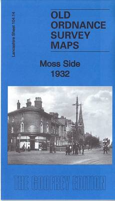
Moss Side 1932 – 104.14c

Related Products:
 On the Side: A Sourcebook of Inspiring Side Dishes
 tarfell: Willow Moss and the Forgotten Tale : 2
 Kearsley (South) & Clifton Moss 1927 – 95.11b
 Gathering Moss: A Natural and Cultural History of Mosses
 Manchester (SW) 1932 – 104.10c
 Southampton (East) 1932 – 65.11b
 Southampton (Portswood & Highfield) 1932 – 65.03
 Salford Docks & Ordsall 1932 – 104.09c
 Moss
Moss
 Southampton NE (Bevois Town & Bitterne) 1932 – 65.07
 Moss Valley and Gwersyllt 1909
 Side by Side
 The Other Side of Lost
 The Wrong Side of the Bed
 Port Side Pirates
 Chadderton North 1932
 Manchester SE & Ardwick 1932 – 104.11b
 The Silly Book of Side-Splitting Stuff
North Surbiton and South Kingston 1932
The Silly Book of Side-Splitting Stuff
North Surbiton and South Kingston 1932
 Lovers at the Chameleon Club, Paris 1932: A Novel
 Henri Cartier-Bresson: Photographs 1932-1946
 Star Wars Be More Vader: Assertive Thinking from the Dark Side
Admiralty Chart Folio 48 – Eastern Side of China Sea and Sulu Sea
Star Wars Be More Vader: Assertive Thinking from the Dark Side
Admiralty Chart Folio 48 – Eastern Side of China Sea and Sulu Sea
 IFLScience! How to F**king Save the Planet: The Brighter Side of the Fight Against Climate Change
 Stanford`s Chart of the Solent, Spithead and Southampton Water (1932) – A2 Wall Map, Canvas
Stanford`s Chart of the Solent, Spithead and Southampton Water (1932) – A1 Wall Map, Canvas
Stanford`s Chart of the Solent, Spithead and Southampton Water (1932) – A2 Wall Map, Canvas
Stanford`s Chart of the Solent, Spithead and Southampton Water (1932) – A1 Wall Map, Canvas
 NOAA Chart 14826 – Moss Point to Vermilion – Beaver Creek – Rocky River – Vermilion Harbor
 Starfell: Willow Moss and the Lost Day (Starfell, Book 1)
 Starfell: Willow Moss and the Lost Day – Starfell, Book 1
Stanford`s Chart of the Solent, Spithead and Southampton Water (1932) – A3 Wall Map, Paper – Print on Demand
Stanford`s Chart of the Solent, Spithead and Southampton Water (1932) – A3 Wall Map, Canvas – Print on Demand
Stanford`s Chart of the Solent, Spithead and Southampton Water (1932) – A2 Wall Map, Paper – Print on Demand
Stanford`s Chart of the Solent, Spithead and Southampton Water (1932) – A1 Wall Map, Paper – Print on Demand
Stanford`s Chart of the Solent, Spithead and Southampton Water (1932) – Original Size Wall Map, Canvas
Stanford`s Chart of the Solent, Spithead and Southampton Water (1932) – Original Size Wall Map, Paper – Print on Demand
Starfell: Willow Moss and the Lost Day – Starfell, Book 1
Stanford`s Chart of the Solent, Spithead and Southampton Water (1932) – A3 Wall Map, Paper – Print on Demand
Stanford`s Chart of the Solent, Spithead and Southampton Water (1932) – A3 Wall Map, Canvas – Print on Demand
Stanford`s Chart of the Solent, Spithead and Southampton Water (1932) – A2 Wall Map, Paper – Print on Demand
Stanford`s Chart of the Solent, Spithead and Southampton Water (1932) – A1 Wall Map, Paper – Print on Demand
Stanford`s Chart of the Solent, Spithead and Southampton Water (1932) – Original Size Wall Map, Canvas
Stanford`s Chart of the Solent, Spithead and Southampton Water (1932) – Original Size Wall Map, Paper – Print on Demand
 Sunny Side Up
 On Canaan`s Side
 Alternate Side
 My Side of the Diamond
 The Far Side of the World