Disclosure : This site contains affiliate links to products. We may receive a commission for purchases made through these links.
Montevideo
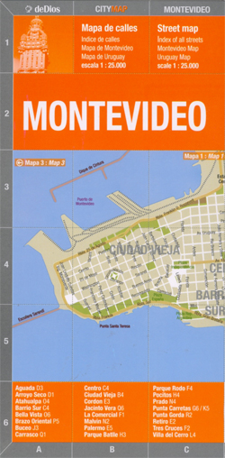
Montevideo in a series of light, laminated and waterproof concertina street plans of Latin American capitals, designed to present each city’s most visited areas. The plans are indexed and include diagrams of metro networks.The plan of Montevideo at 1:25,000 covers the central part of the city from the Old Town to Carrasco, with insets extending in north to the Atahualpa and Brazo Oriental districts and west across the port area to Villa del Cerro. On the reverse is a street index, a diagram of the metro network, lists of main places of interest and useful phone numbers, plus a basic map of Uruguay showing main roads and administrative provinces.

Related Products:
 Santiago de Chile de Dios CityMap
 Montevideo de Dios Map-Guide
 Barcelona Borch
 Kharkov Kartografija Street Plan
 Istanbul Marco Polo City Map
 Bangkok Marco Polo City Map
 Genoa TCI Pocket Plan
 Brussels Marco Polo City Map
 Rome & Southern Italy ITMB
 St Petersburg Marco Polo City Map
 Moscow ITMB
 Hong Kong Marco Polo City Map
 Helsinki City Map
 Cape Town Marco Polo City Map
 Rio de Janeiro Marco Polo City Map
 Osaka & Western Japan ITMB
 Berlin Borch
 Santiago de Chile Trekkingchile Street Plan
 Iran & Tehran ITMB
 Turin TCI Pocket Plan
 Moscow Jana Seta Street Plan
 Warsaw Marco Polo City Map
 Tehran & Northern Iran ITMB
 Palermo TCI Pocket Plan
Madrid Essential Telstar Map
Palermo TCI Pocket Plan
Madrid Essential Telstar Map
 Nuremberg City Pocket Plan
 Uruguay – Montevideo – Maldonado and Punta del Este
 Rome TCI Pocket Plan
 Palma de Mallorca City Map / Mallorca Road Map
 Munich Marco Polo City Map
Naples TCI Pocket Plan
Munich Marco Polo City Map
Naples TCI Pocket Plan
 Athens Borch
Munich Falk Cityplan
Athens Borch
Munich Falk Cityplan
 Rome Michelin Citymap
Nuremberg Falk EXTRA Street Plan
Rome Michelin Citymap
Nuremberg Falk EXTRA Street Plan
 Beijing Borch
 St Petersburg Borch