Disclosure : This site contains affiliate links to products. We may receive a commission for purchases made through these links.
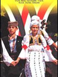
Montenegro & North Albania Gizi Map
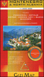
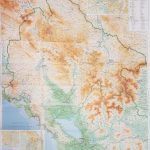
Montenegro and Northern Albania at 1:200,000 from Gizi Map with the publisher’s characteristic, vivid presentation of the topography through bold altitude colouring, an index of localities, plus street plans of central Podgorica, Herceg Novi, Cetinje, Budva, Kotor and Shkodรซr. Coverage within Albania extends south to Lezhรซ and RRรซshen.Bold altitude colouring plus names of mountain ranges, peaks, etc, and additional spot heights presents the topography; the map also shows the boundaries of national parks and other protected areas. Road network is graded in six types, including selected country tracks, and shows driving distances on main and on some smaller roads, plus locations of border crossings. Special cycling routes are highlighted. Railway lines and ferry routes are included and local airports are marked. Symbols highlight various places of interest, including exceptional natural sites. The map has latitude lines at 10’ intervals, with longitude at 15’. The index is on the reverse and includes locations in the neighbouring countries. Street plans of central Podgorica, Herceg Novi, Cetinje, Budva, Kotor and Shkodรซr indicate principal traffic arteries and highlight important buildings. Map legend includes English.PLEASE NOTE: this title is also available as a wall map.

Related Products:
 Montenegro & North Albania Gizi Wall Map
 Albania North
 Serbia North F&B
 Pakistan Gizi Map
 Kazakhstan Geographical Gizi Map
 Albania Central
 Montenegro
 Macedonia Gizi Map
 Vietnam – Laos – Cambodia Gizi Map
 Best of Albania
 Albania ITMB
 Kazakhstan Political Gizi Map
Afghanistan – Kabul & 5 Cities Street Plans Gizi Wall Map
Kazakhstan Political Gizi Map
Afghanistan – Kabul & 5 Cities Street Plans Gizi Wall Map
 Algeria Gizi Geographical Map
 Kyrgyzstan Gizi Map
 Central Asia Geographical Edition Gizi Map
 Syria Gizi Map
 Afghanistan – Kabul & 5 Cities Gizi Map
 Albania South
 St Lucia Gizi Map
 Syria Gizi Wall Map
 China South Gizi Map
 Turkmenistan Gizi Map
 Ukraine – Moldova Gizi Map
 Morocco Gizi Map
 Iran Gizi Map
Turkmenistan Gizi Wall Map
Iran Gizi Map
Turkmenistan Gizi Wall Map
 China Central Gizi Map
 Croatia – Montenegro Coast Cartographia 2-Map Set
 Uzbekistan Gizi Map
 Mali Gizi Map
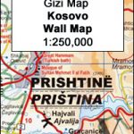 Kosovo Gizi Wall Map
 Uzbekistan Gizi Map Wall Map
 Argentina North & Uruguay ITMB
 Red Sea Gizi Map
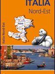 Italy North East Michelin Regional 562
 Mexico ITMB
 Ethiopia – Eritrea – Djibouti Gizi Map
 Montenegro Wilderness Biking Atlas