Disclosure : This site contains affiliate links to products. We may receive a commission for purchases made through these links.
Mongolia ITMB
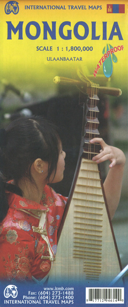
Mongolia on a double-sided, indexed map at 1:1,785,000 from ITMB with altitude colouring to show the country’s topography, plus a large street plan of central Ulaanbaatar annotated with hotels and places of interest. All place names are shown transliterated.The map divides the country east/west with a very generous overlap between the sides. Topography is shown by bold altitude colouring with graphics for swamps, glaciers, sand dunes, water wells, etc. National parks and protected areas are highlighted. Road network indicates partially paved and unpaved roads, includes selected tracks and shows locations of border crossings from Russia or China and petrol stations. Driving distances are shown on main and many local routes. Railway lines are included and domestic airports are marked. The map also shows internal administrative boundaries with names of the provinces and highlights various places of interest. Latitude and longitude lines are drawn at 2ยฐ intervals and each side has a separate index. A large, clear street plan shows the town centre of Ulaanbaatar, highlighting several hotels, foreign embassies, and various places of interest. Also provided is an inset showing the county`s natural zones (taiga, steppe, desert, etc).

Related Products:
 Mongolia (Geographical Edition)
 Mongolia Geographical Edition Wall Map
 Bhutan & Northeast India ITMB
 Pakistan ITMB
 Panama ITMB
 Paraguay – Bolivia South ITMB
 Belarus ITMB
 Togo & Benin ITMB
 Romania & Moldova ITMB
 Taiwan & Taipei ITMB
 Colombia ITMB
 Japan North & Hokkaido ITMB
 Jordan & Syria ITMB
 Algeria ITMB
 Madagascar ITMB
 Angola ITMB
 Sao Paulo & Brazil South Coast ITMB
 Jordan
 China – Mongolia – Taiwan F&B
 Tanzania ITMB
 South America ITMB
 Japan South ITMB Railway & Road Map
 Cuba ITMB
 Kenya ITMB
 Argentina South & Tierra del Fuego ITMB
 Qatar and Doha City ITMB
 Las Vegas ITMB
 Tehran & Northern Iran ITMB
 Saudi Arabia & Kuwait ITMB
 Iran & Tehran ITMB
 Mali ITMB
 Turkmenistan Gizi Map
 Peru ITMB
 San Francisco & Northern California ITMB
 Seattle & Northwest USA ITMB
 Morocco ITMB
 Manhattan & New York State ITMB
 Zurich & Switzerland NW ITMB
 Turkmenistan Gizi Wall Map