Disclosure : This site contains affiliate links to products. We may receive a commission for purchases made through these links.
Minneapolis – St Paul, MN: Twin Cities SuperMap
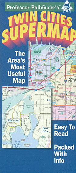
Minneapolis and St Paul area in Minnesota on a double-sided street plan from the locally based Hedberg Maps combining coverage of a wide area around the Twin Cities with a more detailed coverage of the central districts and the I-494 corridor.On one side is a more general map at 1:115,000 approx. showing the network of highways and streets, with an index listing cities and parks. On the reverse the central districts of Minneapolis and St Paul are shown in greater detail at 1:23,000 approx, plus I-494 corridor at 1:40,000 approx. These two maps have no separate street indexes but instead lists of major hotels, shopping centres, arenas and sport venues, golf courses, educational establishments, etc.Both sides clearly indicate principal traffic arteries and connecting main streets and highlight various important buildings and places of interest.

Related Products:
 Moon Minneapolis & St. Paul
 111 Places in the Twin Cities That You Must Not Miss
 Moon 75 Great Hikes Minneapolis & St. Paul
 Philadelphia Red Maps
 Rome Red Maps
 Afghanistan – Kabul & 5 Cities Street Plans Gizi Wall Map
 Boston Red Maps
 Florence Red Maps
 Barcelona Red Maps
 Afghanistan – Kabul & 5 Cities Gizi Map
 San Francisco – Northern Peninsula Cities CA Rand McNally
 Madrid and Seville Red Maps
 Milan Red Maps
Singapore Borch
Milan Red Maps
Singapore Borch
 Washington DC Red Maps
 Australia: UBD Gregory`s Street Maps and Directories
 Brisbane UBD Gregory`s City Pocket 460
 Amsterdam Red Maps
 San Francisco Red Maps
 Congo Cities Map (10 Street Plans)
 Chicago Red Maps
 Vienna Red Maps
 Venice Red Maps
 Berlin – Potsdam Red Maps
 Dublin Red Maps
 Great Britain: A-Z Towns and Cities Street Atlases
 Kyoto & Japan West ITMB
 St Paul`s and Newgate 1873
 Paris Red Maps
 Miami – South Beach Red Maps
 Los Angeles Red Maps
 Santiago de Chile Trekkingchile Street Plan
 Jakarta ITMB
 Underground Cities: Mapping the Tunnels, Transits and Networks of Our Cities
Valreas – Saint-Paul-Trois-Chateaux IGN 3039ET
Underground Cities: Mapping the Tunnels, Transits and Networks of Our Cities
Valreas – Saint-Paul-Trois-Chateaux IGN 3039ET
 Singapore Periplus Travel Map
 Tokyo City Atlas – a Bilingual Guide
 Shanghai Periplus Travel Map
 Australia: Hema Maps of Main Cities and Surrounding Regions
 Sydney & North Sydney UBD Gregory`s City Pocket 260