Disclosure : This site contains affiliate links to products. We may receive a commission for purchases made through these links.
Milos – Kimolos – Polyvos Anavasi 10.45
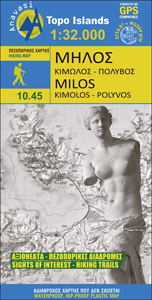
The Aegean island of Milos at 1:32,000 plus on the reverse the nearby islands of Kimolos and Polyvos at 1:26,000 on a light, waterproof and tear-resistant, contoured and GPS compatible map from Anavasi with recommendations for hiking paths and/or special geological trails. All place names are in both Greek and Latin alphabets.The islands’ topography is shown by contours at 20m intervals, enhanced by relief shading and altitude colouring. Road network indicates dirt roads in poor condition and shows locations of petrol stations and driving distances on main roads. The maps distinguish between cart tracks and well defined, narrow or faint footpaths. Symbols highlight various places of interest and facilities, including beaches, caves, archaeological remains, etc, The maps have a 1km UTM grid plus latitude and longitude crosshairs at 1’. On Milos locations of six special signposted ‘geowalks” are highlighted, an inset presents in greater detail the area of the Ancient Milos archaeological site, plus various locations are annotated with brief notes. On Kimolos seven hiking trails are prominently marked and listed with distances, plus another location for a ‘geowalk”. Map legend and all the text include English.To see which other islands are covered by maps from Anavasi, please click on the series link.

Related Products:
 Milos – Kimolos – Polyeghos Terrain Editions 306
 Milos – Kimolos Orama Editions 311
 Western Cyclades: Kea, Kythnos, Seriphos, Siphnos, Milos, Kimolos
 Karpathos – Saria Anavasi 10.50
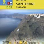 Santorini – Thirasia Anavasi 10.24
 Cephalonia / Kefalonia – Ithaca Anavasi 9.3
 Paxos – Antipaxos Anavasi 9.2
 Sifnos Anavasi 10.26
 Kimolos & Polyaigos 25K Terrain Editions Pocket Map
 Kythnos Anavasi 10.44
 Tinos Anavasi 10.20
 Alonisos – Northern Sporades Marine Park Anavasi 9.2
 Chalki Anavasi 10.33
 Kalymnos – Telendos & Pserimos Anavasi 10.32
 Serifos Anavasi 10.25
 Naxos & Small Cyclades Anavasi 10.28
 Mainalo – Artemisio – Lyrkeio – Farmakas – Ktenias Anavasi 8.5
 Mykonos – Delos – Rheneia / Rineia Anavasi 10.42
 Skiathos Anavasi 10.11
 Sikinos Anavasi 10.29
 Skyros Anavasi 10.14
 Andros Anavasi 10.21
 Cyclades – Argosaronic Anavasi Regional Map R1
 Kea / Tzia Anavasi 10.41
 Chios – Psara – Inouses Anavasi 10.31
 Syros Anavasi 10.22
 Amorgos Anavasi 10.27
 Paros – Antiparos Anavasi 10.23
 Lefkada Anavasi 9.1
 Corfu – Othoni – Erikouse – Mathraki Anavasi 9.4
 Hydra Anavasi 10.40
 Spetses Anavasi 10.30
 Rhodes & Symi Anavasi 10.38
 Zakros – Vai – Sitia Anavasi 11.16
 Psiloritis – Mt Ida Anavasi 11.14
 Macedonia Anavasi Regional Map R4
 Peloponnese Anavasi Regional Map R2
 Greece: Anavasi Maps of Greek Islands
 Greece: Anavasi Hiking Maps of Crete