Disclosure : This site contains affiliate links to products. We may receive a commission for purchases made through these links.
Middle Dalmatian Coast 3 – Brac – Hvar – Split F&B
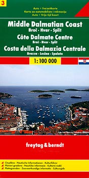
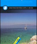
The Dalmatian Coast of Croatia from Split southwards to Gradec on a detailed map at 1:100,000 from Freytag & Berndt with large icons indicating various facilities including campsites and beaches, ferry connections, etc.Coverage includes the islands of Brac, Hvar, Vis, Korcula and Lastovo, plus the northern part of the Peljesac peninsula. The map shows local roads and indicates ferry connections. Icons mark various facilities such as campsites, beaches and marinas, as well as places of interest. The map has latitude and longitude lines but without providing the coordinates. Map legend includes English.Street plans show Split, Hvar, Korcula and Makarska. On the reverse there is a guide to the area, in English, with plans of local marinas, etc. Please note: this title is not a nautical chart for sailing.

Related Products:
 Dalmatian Coast 2 – Sibenik – Split – Vis F&B
 Middle Dalmatian Coast 4 – Mljet – Medugorje – Dubrovnik F&B
 Dalmatian Coast 1 – Zadar – Kornati Islands F&B
 Dalmatian Coast F&B Top 10 Tips
 DK Eyewitness Top 10 Dubrovnik and the Dalmatian Coast
 M26 Split to Dubrovnik
 Dalmatian Coast North – Krk ‘“ Cres ‘“ Loลกinj ‘“ Rab ‘“ Pag – Zadar Kompass 2901
 Croatia – Dalmatian Coast 3-Map Set Kompass 2900
 Lonely Planet Pocket Dubrovnik & the Dalmatian Coast
 Croatia/Montenegro: MairDumont Marco Polo 200K Road Maps of the Dalmatian Coast
 Croatia: Kompass 100K Maps of the Dalmatian Coast
Croatian Coast K+F Road Map
Croatia: Kompass 100K Maps of the Dalmatian Coast
Croatian Coast K+F Road Map
 Stockholm County Norstedts Road Map
 Croatia: Freytag & Berndt Maps of the Croatian Coast
 Coast Around Lisbon Turinta
 Philippines F&B
 Etruscan Coast – Pisa – Livorno – Piombino Global Map Tourist Map
 Croatia – Montenegro Coast Cartographia 2-Map Set
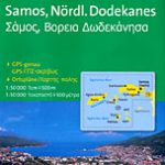 Samos & Northern Dodecanese Islands 50K Kompass Map No.253
 Brac Island
 Lake Constance F&B Touring Map
 Bay of Naples – Ischia – Capri – Amalfitana F&B
 Aeolian (Lipari) Islands and Southern Italy F&B
 Fuerteventura F&B
 Dalmatia – Croatia Coast Central and South
 Gran Canaria F&B WKE5
Lake Constance F&B Leisure & Panorama
Montenegro Coast
Gran Canaria F&B WKE5
Lake Constance F&B Leisure & Panorama
Montenegro Coast
 Turkey – Middle East Road Map
 Faroe Islands
 Mayotte IGN Map 84976
 Iceland F&B
 Dalmatia – Istria
 South Africa – Lesotho – Swaziland ITMB
 Tuscany Borch
 Bulgarian and Romanian Coast
Croatia & Montenegro – Adriatic Coast ExpressMap
Bulgarian and Romanian Coast
Croatia & Montenegro – Adriatic Coast ExpressMap
 Dalmatia 2-Map Set
 SHOM Chart 7695 – Split – Kastelanski Zaljev