Disclosure : This site contains affiliate links to products. We may receive a commission for purchases made through these links.
Miami – Fort Lauderdale – West Palm Beach FL Regional Rand McNally
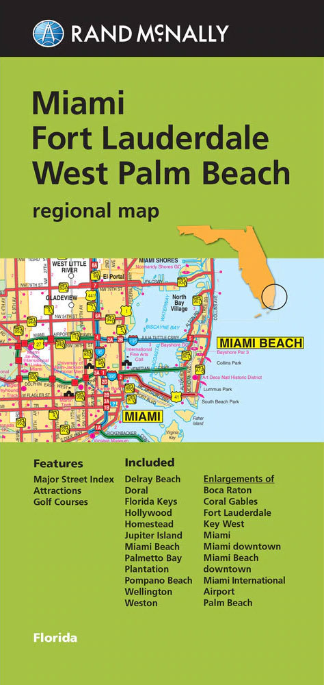
The eastern half of southern Florida with Miami, Fort Lauderdale and West Palm Beach in a series of Rand McNally’s regional road maps covering the environs of main US cities. Coverage along the coast extends from Jupiter Island to Key Largo and the northern part of Florida Keys. Other communities covered by the map include Boca Raton, Coral Gables, Delray Beach, Doral, Hollywood, Homestead, Palm Beach, Palmetto Bay, Plantation, Pompano Beach, Tequesta, Wellington, and Weston. Also provided is a street plan of downtown Miami.Maps in this series present the road network on a clear background with no relief shading to show the area’s topography, but with national or state parks, forests and other protected areas indicated by colouring. Roads are numbered and/or named, showing toll highways, exit numbers of interchanges, services and rest areas. Local airports are marked, but railways and other urban transport lines are not included unless specifically indicated in the individual description. Each town is presented in a different colour, providing those unfamiliar with the region a very clear picture of the area. Various places of interest and facilities are highlighted, including cultural and historical sites, educational institutions, sport and recreational facilities, etc. Each title is indexed. Several maps also include enlargements of the downtown area, plans of international airports, a mileage and driving times diagram for a much wider region than covered by the main map, etc – for more information please see the individual descriptions.To see all the titles in this series please click on the series link.

Related Products:
 Dallas – Fort Worth Regional TX Rand McNally
 Florida Central & Eastern Regional Rand McNally
 Denver Regional CO Rand McNally
 USA: Rand McNally Regional Maps
 Los Angeles & San Diego Vicinity CA Regional Rand McNally
 Indianapolis & Vicinity IN Regional Rand McNally
 Pittsburgh Regional PA Rand McNally
 Portland Regional Rand McNally
 San Francisco Bay Area CA Regional Rand McNally
 Phoenix – Tucson & Vicinity AZ Regional Rand McNally
 Detroit & Southeastern Michigan Regional Rand McNally
 Chicago Regional Rand McNally
 Fort Lauderdale Metro FL Rand McNally
 Philadelphia & Southeast Pennsylvania Regional Rand McNally
 Puget Sound WA Regional Rand McNally
 Tampa – St. Petersburg – Ocala to Sarasota Regional Rand McNally
 Houston TX Regional Rand McNally
 Miami FL Rand McNally
 Greater Boston – Eastern Massachusetts Regional Rand McNally
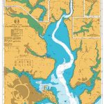
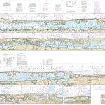
 NOAA Chart 11467 – Intracoastal Waterway’”West Palm Beach to Miami
 New York City & Long Island Regional Rand McNally
Charlotte NC Rand McNally
New York City & Long Island Regional Rand McNally
Charlotte NC Rand McNally
 Fodor`s South Florida: With Miami, Fort Lauderdale, and the Keys
 Miami – South Beach Red Maps
 NOAA Chart 11472 – Intracoastal Waterway’”Palm Shores to West Palm Beach – Loxahatchee River
 Miami & South Florida ITMB
 Fort Myers – Cape Coral FL Rand McNally
 Florida Easy-to-Read Rand McNally
 Miami Borch
 111 Places in Palm Beach That You Must Not Miss
 Fort Worth TX Rand McNally
 Miami PopOut
 USA: Rand McNally Street Plans / Regional Maps
 Palm Beach, Finland
 Jacksonville FL Rand McNally
 San Diego CA Rand McNally
 California Easy-to-Read Rand McNally
 Anchorage – Fairbanks – Juneau – Ketchikan AK Rand McNally
 Miami & the Keys NGS City Destination Map
 Des Moines – Ames IA Rand McNally