Disclosure : This site contains affiliate links to products. We may receive a commission for purchases made through these links.
Miami FL Rand McNally
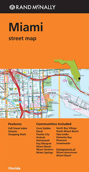
Miami with Miami Beach in Florida on an indexed street plan from Rand McNally in their extensive range of maps covering cities in the United States. The map includes more detailed enlargements of downtown Miami with Miami Beach. Other communities covered by this title include Coral Gables, Doral, Florida City, Hialeah, Homestead, Key Biscayne, Miami Gardens, Miami Springs, North Bay Village, North Miami Beach, Op-Locka, Palmetto Bay, Pinecreast and Sweetwater.NEW STREET PLAN CARTOGRAPHY FROM RAND McNALLY: Rand McNally are currently changing the cartography of their street plans to a more ‘European” style. In many titles streets are now shown by parallel lines, providing a much clearer, easier to read presentation. Better use of colouring indicates different types of land use and/or institutions (parks, shopping centres, academic institutions, etc) and, in most titles, different administrative units. More streets are annotated with block numbers. Some new editions still retain the traditional American presentation of streets by a single line, but with more prominent marking for various institutions, facilities and places of interest. Our cartography sample indicates which style is used in this title.COVERAGE: Rand McNally street plans cover cities with their outer suburbs, prominently highlighting principal traffic arteries and connecting main streets. Railway and subway stations are marked.

Related Products:
 Fort Lauderdale Metro FL Rand McNally
 Albuquerque NM Rand McNally
 Phoenix AZ Rand McNally
 Memphis TN Rand McNally
 Charleston SC Rand McNally
 Spokane WA Rand McNally
 San Diego CA Rand McNally
 Chicago IL Rand McNally
 San Antonio TX Rand McNally
 Cleveland – Cuyahoga County OH Rand McNally
 Atlanta GA Rand McNally
 Indianapolis IN Rand McNally
 Raleigh – Durham NC Rand McNally
 Pittsburgh PA Rand McNally
 Cincinnati OH Rand McNally
 Philadelphia PA Rand McNally
 Rochester NY Rand McNally
 San Francisco – Northern Peninsula Cities CA Rand McNally
 Boston MA Rand McNally
 Portland OR Rand McNally
 Buffalo – Niagara Falls NY Rand McNally
 New Orleans LA Rand McNally
 Sacramento CA Rand McNally
 Dallas TX Rand McNally
 Seattle WA Rand McNally
 Orlando FL Rand McNally
 Houston TX Rand McNally
 Denver CO Rand McNally
 Austin – Georgetown – Round Rock TX Rand McNally
 Salt Lake City UT Rand McNally
 Columbus OH Rand McNally
Nashville TN Rand McNally
Columbus OH Rand McNally
Nashville TN Rand McNally
 St Louis MO Rand McNally
 Milwaukee WI Rand McNally
USA: Rand McNally Street Plans / Regional Maps
Los Angeles CA Rand McNally
Las Vegas – North Las Vegas – The Strip NV Rand McNally
Milwaukee WI Rand McNally
USA: Rand McNally Street Plans / Regional Maps
Los Angeles CA Rand McNally
Las Vegas – North Las Vegas – The Strip NV Rand McNally
 Miami – Fort Lauderdale – West Palm Beach FL Regional Rand McNally
 Jacksonville FL Rand McNally
 Florida Easy-to-Read Rand McNally