Disclosure : This site contains affiliate links to products. We may receive a commission for purchases made through these links.
Mexico NGS Adventure Map 3108
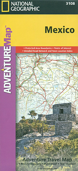
Mexico at 1:2,425,000 in a series of Adventure maps from the National Geographic Society with cartography provided by Reise Know-How. The map, double-sided and printed on light waterproof and tear-resistant plastic paper, divides Mexico north/south with a generous overlap between the sides. Coverage extends south to include the whole of Belize, most of Guatemala (well past Guatemala City) and north-western Honduras including Tegucigalpa.Cartographic information provided by Reise Know-How has been adjusted to follow the house style of the NGS Adventure series with greater emphasis on the country’s topography. Altitude colouring in broader bands has been replaced here by contours at 200m intervals, enhanced by relief shading with graphics for swamp areas, mangroves, seasonal rivers and lakes, and along the coast coral reefs. Boundaries of national parks and other protected areas are very prominently highlighted.Road network indicates toll routes, includes selected local roads and tracks, and shows border crossings and distances on main routes. Railway lines are included and local airports are marked. Internal administrative boundaries are shown with names of the provinces. Symbols indicate numerous places of interest, including UNESCO world heritage sites, castles and archaeological sites, etc. The map has a latitude and longitude grid at intervals of 2ยฐ and an extensive index of localities.Overall, the NGS map presents a more vivid picture of the country’s topography, whilst the original RK-H version provides clearer information for touring the country by road or rail.PLEASE NOTE: to ensure regular supplies and faster delivery to our customers we keep as regular stock the Reise Know-How edition whilst the NGS version can be ordered on request.

Related Products:
 New Zealand Adventure Map
 Argentina NGS Adventure Map 3400
 Mexico Reise Know-How
 South Africa Adventure Map
 Australia Adventure Map
 Thailand Adventure Map
 Tuscany Adventure Map
 Sicily NGS Adventure Map 3310
 Nicaragua – Honduras – El Salvador NGS Adventure Map 3109
 Ecuador – Galapagos NGS Adventure Map 3403
 Peru NGS Adventure Map 3404
 India South Adventure Map
 China Adventure Map
 Vietnam North NGS Adventure Map 3015
 Vietnam South NGS Adventure Map 3016
 India Northeast NGS Adventure Map 3012
 Slovenia Adventure Map
 Egypt NGS Adventure Map 3202
 Southern Sweden and Norway Adventure Map
 Morocco NGS Adventure Map 3203
 Finland and Northern Scandinavia NGS Adventure Map 3300
 Sardinia NGS Adventure Map 3309
 Mexico ITMB
 Brazil NGS Adventure Map 3401
 Mexico Road Map
 Chile NGS Adventure Map 3402
 Mexico Nelles
 Italy NGS Adventure Map 3304
 India Adventure Map
 Northern Spain NGS Adventure Map 3306
 Guatemala NGS Adventure Map 3110
 Australia East Adventure Map
 Southern France Adventure Map
 Mexico: NGS Adventure Maps
 China East Adventure Map
 Mexico Central & Mexico City ITMB
 Mexico North ITMB
 Guatemala – Belize Reise Know-How
 Mexico NGS Executive Wall Map PAPER
 Mexico Michelin