Disclosure : This site contains affiliate links to products. We may receive a commission for purchases made through these links.
Merano and Surroundings Freytag & Berndt Map
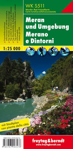
One of the titles in Freytag & Berndt’s series of hiking maps of Dolomites. The maps have contours at 100-metre intervals. An overprint highlights footpaths, including all nine Alte Vie – the Dolomites High Level Routes, with cycling, mountain bike, and ski routes also shown on some of the titles. The maps show mountain refuges, campsites, youth hostels, etc. Geographical coordinates vary from margin ticks showing latitude and longitude in steps of 5` to a UTM grid – please see individual descriptions. Map legend includes English.This title includes: UTM grid, GPS waypoints, index, cycle and mountain bike routes, ski routes, a booklet with description of the area in German and Italian only plus a street plan of Merano.

Related Products:
 Val Venosta/Vinschgau Freytag & Berndt Map
 Merano and Surroundings Kompass 53
 Dolomiti di Sesto / Sextener Dolomiten – Cortina d`Ampezzo F&B WKS10
 Rรผgen Freytag & Berndt Map
 Silandro / Schlanders and Surroundings – Val Martello / Martelltal Kompass 069
 Merano Kompass 053
 Germany: Freytag & Berndt Hiking and Leisure Maps
 Texelgruppe NP – Merano High Route Kompass 043
 Gesรคuse – Ennstaler Alpen – Schoberpass Freytag & Berndt Map
 Italy: F&B Walking Maps of the Dolomites
 Gleinalpe – Lippizanerheimat – Leoben – Voitsberg Freytag & Berndt Map
 Austria: Freytag & Berndt Hiking Maps
 Attersee – Mondsee – Wolfgangsee Freytag & Berndt Map
 Otscherland – Mariazell – Erlauftal – Lunzer See – Scheibbs Freytag & Berndt Map
 Saualpe – Lavanttal – Koralpe – Region Schlicherheimat Freytag & Berndt Map
 Croatia: Freytag & Berndt Maps of the Croatian Coast
 Bohemian Forest – Mรผhlviertel – Moldau/Vltava Reservoir Freytag & Berndt Map
 Thayatal National Park – Znaim – Retz – Gars am Karp Freytag & Berndt Map
 Merano and the Surrounding Area Tabacco 011
 Grossglockner – Heiligenbult – Sonnblick – Shobergruppe – Oberes Mรถlltal Freytag & Berndt Map
 Austria: Freytag & Berndt Cycling Maps
 Austria: Freytag & Berndt 200K Road Maps
 Croatia: Freytag & Berndt 200K Regional Road Maps
 Inn Bike Trail: Landeck – Passau Freytag & Berndt Map
 Kamp – Thaya – March Bike Trail Freytag & Berndt Map
 Tauern Bike Trail: Krimml – Passau Freytag & Berndt Map
 Brunico / Bruneck – Plan de Corones / Kronplatz Kompass 045
 Poland F&B Postcode Freytag & Berndt Wall Map
 Austria: Freytag & Berndt 150K “Top 10 Tips” Road Maps
 Italy: Freytag & Berndt “Top 10 Tips” Road Maps
 Vorarlberg Cycling Freytag & Berndt Map
 Weinviertel Cycling Freytag & Berndt Map
 Elba Kompass 2468
 Austria Freytag & Berndt Panorama Wall Map
 Germany: Freytag & Berndt “Top 10 Tips” Road Maps
 Lake Garda – Monte Baldo Kompass 102
 Val di Funes / Villnรถsstal Kompass 627
 South Tyrol – Dolomites 4-Map Set Kompass 699
 Alpi Bellunesi Kompass 77
 Ischia and Procida Islands Kompass 680