Disclosure : This site contains affiliate links to products. We may receive a commission for purchases made through these links.
Massif de la Vanoise IGN 75003
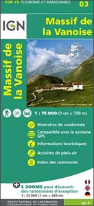
Vanoise Massif and the National Park region in a series of GPS compatible, contoured TOP 75 maps at 1:75,000 from the IGN, highlighting local and long-distance hiking paths, cycling routes and sites for other recreational activities. The map includes five large panels showing the areas around Mont Jovet, Champagny-en-Vanoise, Pointe de l’Echelle, Lac de la Plagne, and Col de Chaviรจre on IGN’s topographic mapping at 1:25,000 with extensive overprint for local hiking paths and tourist facilities including campsites.Cartography of the main map at 1:75,000 is a direct enlargement of the mapping used in the IGN’s TOP100 series. Contours are at 40m intervals, enhanced by relief shading; additional colouring shows different types of vegetation (woods, brushwood, vineyards/orchards). Boundaries of national parks and other protected areas are marked. An overprint highlights long-distance GR hiking routes and cycling trails. Symbols – more numerous than on the TOP100 maps – indicate various places of interest including mountain refuges and gรฎtes d’etape (campsites on the enlargements), areas for other recreational pursuits such as climbing, hand gliding or water and winter sports, historic or cultural sites, etc. The map has a UTM grid and an index of communes. Map legend includes English.Coverage of the main map extends from Albertville in the north-western corner to just below the A43 motorway leading to Modane. Other locations include Bourg-St-Maurice, la Rosiรจre, Sรฉez, Ste-Foy-Tarentaise, Tignes, Val d’Isรจre, la Plagne, les Arces, Moรปtiers, Aiguebelle, Aigueblanche, Aime, Bozel, Courchevel, St-Martin-de-Belleville, St-Jean-de-Maurienne, St-Michel-de-Maurienne, Aussois, Termignion, Lanslebourg, Lanslevillard, Bessans, Boneval-sur-Arc, as well as the peaks of the Vanoise Massif: Mont Pourri, Dรดme de la Sache, La Grande Casse, La Grande Motte, La Dent Parrachรฉe and Aiguille de Pรฉclet, Massif du Mont Cenis, Col de l’Iseran, etc.To see the list of other maps in this series please click on the series link.


