Disclosure : This site contains affiliate links to products. We may receive a commission for purchases made through these links.
Marseille IGN Street Map

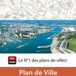
Street plan of Marseille at 1:13,000 from the Institut Gรฉographique National, the country’s national survey organization. Two enlargements show in greater detail the town centre around the central railway station (Gare St-Charles) and the Old Port, plus the Malmousque district. An inset extends coverage by the plan to the north-west to include the whole of the commecial port area. Also provided is a diagram of Marseille’s metro tram network.IGN street plans include outer suburbs and, where appropriate, adjoining localities forming part of the urban agglomeration. The plans prominently highlight principal traffic arteries and show one way streets, car parks and pedestrian zones. Latest editions also indicate 24h petrol stations and streets with separate cycle paths. Many streets are annotated with selected house for easier identification of addresses. Important public buildings are named and symbols mark locations of tourist information centres and other facilities. Street index, arranged by an administrative area, is next to the map. Map legend includes English.PLEASE NOTE: to see the list of IGN street plans of French towns and cities please click on the series link ‘“ the series description also includes a comparison between IGN and Blay-Foldex street plans.

Related Products:
 Marseille Blay-Foldex Street Plan
 Marseille and Surroundings Blay-Foldex Street Atlas
 Avignon IGN Street Map
 Clermont-Ferrand IGN Street Map
 Nice IGN Street Map
 Reims IGN Street Map
 Cannes – Antibes IGN Street Map
 France: IGN Street Plans
 Paris IGN WATERPROOF Street Map
 Pau Blay-Foldex Street Plan
 Hyรจres Blay-Foldex Street Plan
 Mรขcon Blay-Foldex Street Plan
 Nantes Blay-Foldex Street Plan
 Strasbourg Blay-Foldex Street Plan
 Nice Blay-Foldex Street Plan
 Dijon Blay-Foldex Street Plan
 La Rochelle Blay-Foldex Street Plan
 Tours Blay-Foldex Street Plan
 Grenoble Blay-Foldex Street Plan
 Aix-en-Provence Blay-Foldex Street Plan
 Rouen Blay-Foldex Street Plan
 Nancy Blay-Foldex Street Plan
 Caen Blay-Foldex Street Plan
 Lille Blay-Foldex Street Plan
 Le Mans Blay-Foldex Street Plan
 Avignon Blay-Foldex Street Plan
 Toulon Blay-Foldex Street Plan
 Poitiers Blay-Foldex Street Plan
 Sete Blay-Foldex Street Plan
 Troyes Blay-Foldex Street Plan
 Brest Blay-Foldex Street Plan
 Vannes Blay-Foldex Street Plan
 Montauban Blay-Foldex Street Plan
 Valence Blay-Foldex Street Plan
 Amiens Blay-Foldex Street Plan
 Paris Blay-Foldex Street Plan
 Niort Blay-Foldex Street Plan
 Lorient Blay-Foldex Street Plan
 Auxerre Blay-Foldex Street Plan
 Quimper Blay-Foldex Street Plan