Disclosure : This site contains affiliate links to products. We may receive a commission for purchases made through these links.
Marrakesh & Northern Morocco ITMB
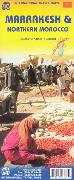
Street plan of Marrakesh backed by a map of northern Morocco (i.e. the whole country without the Western Sahara), with additional smaller plans of Rabat with Sale, Tangier and Casablanca, printed on light, waterproof and tear-resistant plastic paper.On one side is a map of the country extending south beyond 28ยบ, i.e. not covering the Western Sahara. Altitude colouring and spot heights (in feet), plus names of peaks, valleys, etc, show the topography, clearly presenting the course of the Atlas Mountains. Oasis, salt flats, hot spring and waterholes are also marked.Road network includes selected minor roads and local track and indicates locations of petrol stations. Driving distances are indicated on main routes. The map also shows the railway network and local airports. Symbols mark various places of interest and facilities: tourist accommodation including campsites and rest houses, historical and archaeological sites, beaches, caves, etc. The map is indexed and has longitude lines at intervals of 1ยฐ, with latitude shown only as margin ticks.On the reverse is a full size, indexed street plan of Marrakesh at 1:7,400, covering both the Medina and the modern part of the city between it and the railway station. Selected hotels and other facilities, as well as various municipal institutions are marked, including taxi ranks, banks, etc. Within the Medina its various neighbourhoods and main streets are named and an enlargement presents its central part with the main souks in greater detail.The map also includes insets with smaller plans of central Rabat with Sale, Tangier and Casablanca, highlighting road arteries and naming main streets.

Related Products:
 Morocco ITMB
 Kyoto & Japan West ITMB
 Delhi & Northern India ITMB
 Philadelphia & Mid-Atlantic States ITMB
 Osaka & Western Japan ITMB
 Munich & Bavaria ITMB
 Zurich & Switzerland NW ITMB
 Tehran & Northern Iran ITMB
 Quito & Central Ecuador ITMB
 Iran & Tehran ITMB
 Chad ITMB
 Santiago & Chile North ITMB
 Morocco F&B
 Saudi Arabia & Kuwait ITMB
 Paris & France North ITMB
 Easter Island & Santiago ITMB
 Moscow ITMB
 Sydney & Australia East ITMB
 Chile ITMB
Brazil ITMB
Chile ITMB
Brazil ITMB
 Jakarta ITMB
 Helsinki & Southern Finland ITMB
 Western & Northern Canada ITMB Travel Atlas
 Manhattan & New York State ITMB
 Belarus ITMB
 Brazil HARDCOVER ITMB
Sri Lanka & India South ITMB
Kabul & Historic Khyber Pass ITMB
Brazil HARDCOVER ITMB
Sri Lanka & India South ITMB
Kabul & Historic Khyber Pass ITMB
 California ITMB
 Kuwait & Kuwait City ITMB
 Oslo / Bergen & South of Norway ITMB
 Geneva & Switzerland ITMB
 Iceland ITMB
 Reykjavik & SW Iceland ITMB
 Istanbul & Northwest Turkey ITMB
 Hungary & Budapest ITMB
 Lima & Central Peru ITMB
 Cuba ITMB
 San Diego & USA South West Border ITMB
 Tel Aviv-Jaffa & Central Israel ITMB