Disclosure : This site contains affiliate links to products. We may receive a commission for purchases made through these links.
Mar Menor CNIG Protected Areas Map

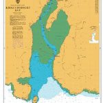
Mar Menor Lagoon with the surrounding mainland and the La Manga sandbar presented at 1:25,000 on a contoured and GPS compatible map from IGN/CNIG, Spain civilian survey organization, with cartography from the country’s topographic survey series. The map provides all the detail expected of topographic mapping at this scale: contour lines are at 10m intervals, colouring and/or graphics indicate different types of vegetation and land use. Symbols indicate various landmarks and campsites are marked. The map has a 1-km UTM grid plus latitude and longitude margin ticks at 1’ intervals. Map legend is in Spanish only.

Related Products:
 Mar Menor CNIG Map
 Sencelles 25K Mallorca CNIG Topographic Survey Map No. 699-I
Sineu 25K Mallorca CNIG Topographic Survey Map No. 699-II
Algaida 25K Mallorca CNIG Topographic Survey Map No. 699-III
Porreres 25K Mallorca CNIG Topographic Survey Map No. 699-IV
Santandria 25K Menorca CNIG Topographic Survey Map No. 646-I
Alaior 25K Menorca CNIG Topographic Survey Map No. 646-II
Es Grau 25K Menorca CNIG Topographic Survey Map No. 647-I
S`Espalmador 25K Formentera CNIG Topographic Survey Map No. 824-II/825-I
Cala en Porter 25K Menorca CNIG Topographic Survey Map No. 646-IV
Pilar de la Mola 25K Formentera CNIG Topographic Survey Map No. 825-III/850-I
Galatzo 25K Mallorca CNIG Topographic Survey Map No. 697-II
Can Picafort 25K Mallorca CNIG Topographic Survey Map No. 672-I
Cap Blanc 25K Mallorca CNIG Topographic Survey Map No. 723-IV
Illa des Conills 25K CNIG Topographic Survey Map No. 748-III
Illa de Cabrera 25K CNIG Topographic Survey Map No. 774-I
Es Cubells 25K Ibiza CNIG Topographic Survey Map No. 798-III
Arta 25K Mallorca CNIG Topographic Survey Map No. 672-IV
Sencelles 25K Mallorca CNIG Topographic Survey Map No. 699-I
Sineu 25K Mallorca CNIG Topographic Survey Map No. 699-II
Algaida 25K Mallorca CNIG Topographic Survey Map No. 699-III
Porreres 25K Mallorca CNIG Topographic Survey Map No. 699-IV
Santandria 25K Menorca CNIG Topographic Survey Map No. 646-I
Alaior 25K Menorca CNIG Topographic Survey Map No. 646-II
Es Grau 25K Menorca CNIG Topographic Survey Map No. 647-I
S`Espalmador 25K Formentera CNIG Topographic Survey Map No. 824-II/825-I
Cala en Porter 25K Menorca CNIG Topographic Survey Map No. 646-IV
Pilar de la Mola 25K Formentera CNIG Topographic Survey Map No. 825-III/850-I
Galatzo 25K Mallorca CNIG Topographic Survey Map No. 697-II
Can Picafort 25K Mallorca CNIG Topographic Survey Map No. 672-I
Cap Blanc 25K Mallorca CNIG Topographic Survey Map No. 723-IV
Illa des Conills 25K CNIG Topographic Survey Map No. 748-III
Illa de Cabrera 25K CNIG Topographic Survey Map No. 774-I
Es Cubells 25K Ibiza CNIG Topographic Survey Map No. 798-III
Arta 25K Mallorca CNIG Topographic Survey Map No. 672-IV
 Haria 25K Lanzarote CNIG Topographic Survey Map No. 1080-IV
Sabinosa 25K Hierro CNIG Topographic Survey Map No. 1105-III
Tetir 25K Fuerteventura CNIG Topographic Survey Map No. 1090-II
Tinajo 25K Lanzarote CNIG Topographic Survey Map No. 1082-I
Vallehermoso 25K La Gomera CNIG Topographic Survey Map No. 1095-III
Los Verodes 25K Fuerteventura CNIG Topographic Survey Map No. 1099-II
La Lajita 25K Fuerteventura CNIG Topographic Survey Map No. 1100-I
Candelaria 25K Tenerife CNIG Topographic Survey Map No. 1092-II
Telde 25K Spain CNIG Topographic Survey Map No. 1104-IV
El Roque 25K Fuerteventura CNIG Topographic Survey Map No. 1086-I
El Castillo 25K Fuerteventura CNIG Topographic Survey Map No. 1094-I
Port de Benirras 25K Ibiza CNIG Topographic Survey Map No. 772-II
Isla de Alegranza 25K CNIG Topographic Survey Map No. 1079-II
San Antoni de Portmany 25K Ibiza CNIG Topographic Survey Map No. 798-I
La Restinga 25K Hierro CNIG Topographic Survey Map No. 1108-I/II
Pajara 25K Fuerteventura CNIG Topographic Survey Map No. 1093-III/IV
San Sebastian de la Gomera 25K CNIG Topographic Survey Map No. 1101-II
Alqueria Blanca 25K Mallorca CNIG Topographic Survey Map No. 725-III
Betlem – Cap Ferrutx 25K Mallorca CNIG Topographic Survey Map No. 672-II
Esporles CNIG Topographic Map 670-9
El Tablero 25K Gran Canaria CNIG Topographic Survey Map No. 1107-III
Pino de la Virgen 25K La Palma CNIG Topographic Survey Map No. 1083-III
Haria 25K Lanzarote CNIG Topographic Survey Map No. 1080-IV
Sabinosa 25K Hierro CNIG Topographic Survey Map No. 1105-III
Tetir 25K Fuerteventura CNIG Topographic Survey Map No. 1090-II
Tinajo 25K Lanzarote CNIG Topographic Survey Map No. 1082-I
Vallehermoso 25K La Gomera CNIG Topographic Survey Map No. 1095-III
Los Verodes 25K Fuerteventura CNIG Topographic Survey Map No. 1099-II
La Lajita 25K Fuerteventura CNIG Topographic Survey Map No. 1100-I
Candelaria 25K Tenerife CNIG Topographic Survey Map No. 1092-II
Telde 25K Spain CNIG Topographic Survey Map No. 1104-IV
El Roque 25K Fuerteventura CNIG Topographic Survey Map No. 1086-I
El Castillo 25K Fuerteventura CNIG Topographic Survey Map No. 1094-I
Port de Benirras 25K Ibiza CNIG Topographic Survey Map No. 772-II
Isla de Alegranza 25K CNIG Topographic Survey Map No. 1079-II
San Antoni de Portmany 25K Ibiza CNIG Topographic Survey Map No. 798-I
La Restinga 25K Hierro CNIG Topographic Survey Map No. 1108-I/II
Pajara 25K Fuerteventura CNIG Topographic Survey Map No. 1093-III/IV
San Sebastian de la Gomera 25K CNIG Topographic Survey Map No. 1101-II
Alqueria Blanca 25K Mallorca CNIG Topographic Survey Map No. 725-III
Betlem – Cap Ferrutx 25K Mallorca CNIG Topographic Survey Map No. 672-II
Esporles CNIG Topographic Map 670-9
El Tablero 25K Gran Canaria CNIG Topographic Survey Map No. 1107-III
Pino de la Virgen 25K La Palma CNIG Topographic Survey Map No. 1083-III