Disclosure : This site contains affiliate links to products. We may receive a commission for purchases made through these links.
Map of the Isles of Scilly Wall Map ENCAPSULATED


Related Products:
 British Isles Political Wall Map SMALL ENCAPSULATED
 British Isles Map Marketing Route Planning Wall Map ENCAPSULATED
British Isles Global Mapping Political Wall Map ENCAPSULATED
British Isles Map Marketing Route Planning Wall Map ENCAPSULATED
British Isles Global Mapping Political Wall Map ENCAPSULATED
 British Isles Wall Map lemon – orange – thistle – khaki ENCAPSULATED
 Admiralty Chart SC5603_12 – Isles of Scilly Saint Martin`s and the Eastern Isles
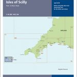 Y49 Isles of Scilly
 British Isles Map Marketing Sales & Marketing Wall Map ENCAPSULATED
 Isles of Scilly Pilot
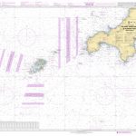
 Admiralty Chart 34 – Isles of Scilly
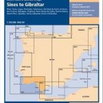
 The West Country: Lyme Bay to the Isles of Scilly
 C7 Falmouth to Isles of Scilly & Trevose Head
 Wild Food Foraging in Cornwall and the Isles of Scilly
Imray Chart: Laminated Isles of Scilly 2400.3
Wild Food Foraging in Cornwall and the Isles of Scilly
Imray Chart: Laminated Isles of Scilly 2400.3
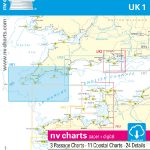 UK1 Isles of Scilly to Start Point – 2019/20 Edition
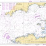
 Admiralty Chart 1148 – Isles of Scilly to Land`s End
 Land`s End & Isles of Scilly – St Ives & Lizard Point OS Landranger 203
 Where to Watch Birds in Devon and Cornwall – incl Isles of Scilly
 Land`s End & Isles of Scilly – St Ives & Lizard Point OS Landranger 203 ACTIVE
 Walking in the Isles of Scilly: 11 walks and 4 boat trips exploring the best of the islands
 Isles of Scilly Map
Isles of Scilly 1896
Isles of Scilly Map
Isles of Scilly 1896
 Cornwall & The Isles Of Scilly
 SHOM Chart 7311 – La Manche (partie Ouest) – De Isles of Scilly et de l’Ile d’Ouessant aux Casquets
 SHOM Chart 6967 – De Saint Agnes Head ร Dodman Point – Isles of Scilly
 Isles of Scilly OS Explorer Map 101 (paper)
 Land`s End and Isles of Scilly 1900
 Birds of Cornwall and the Isles of Scilly
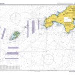 Admiralty Chart 2565 – Saint Agnes Head to Dodman Point including the Isles of Scilly
 Isles of Scilly OS Explorer Active Map 101 (waterproof)
 The Geology and Landscape of Cornwall and the Isles of Scilly
SHOM Chart 7311L – La Manche (partie Ouest) – De Isles of Scilly et de l’Ile d’Ouessant aux Casquets – Leisure A4 size
SHOM Chart 6967L – De Saint Agnes Head ร Dodman Point – Isles of Scilly – Leisure A4 size
The Geology and Landscape of Cornwall and the Isles of Scilly
SHOM Chart 7311L – La Manche (partie Ouest) – De Isles of Scilly et de l’Ile d’Ouessant aux Casquets – Leisure A4 size
SHOM Chart 6967L – De Saint Agnes Head ร Dodman Point – Isles of Scilly – Leisure A4 size
 Scilly Isles Flag (Cross) – 1/2 yard – Printed
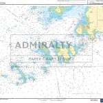
Admiralty Chart SC5603_14 – Land`s End to Isles of Scilly
Scilly Isles Flag (Cross) – 1/2 yard – Printed
Admiralty Chart SC5603_14 – Land`s End to Isles of Scilly
 Admiralty Chart SC5603_8 – Isles of Scilly Southern Part
 Admiralty Chart SC5603_9 – Isles of Scilly Northern Part
 Isles of Scilly Guidebook: St Mary`s, St Agnes, Bryher, Tresco, St Martin`s
 Friendly Guides: Lizard Peninsula and Isles of Scilly Pocket Map Colletions
 Friendly Guides: Lizard Peninsula and Isles of Scilly walking maps
 Admiralty Chart SC5603_11 – Isles of Scilly Saint Mary`s Pool to Tresco