Disclosure : This site contains affiliate links to products. We may receive a commission for purchases made through these links.
Mallorca North Walking & Cycling Map & Guide Editorial Alpina
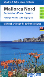
Mallorca North Walking & Cycling Map & Guide set from Editorial Alpina, with a double-sided, contoured and GPS compatible map at 1:25,000, plus a booklet with English language descriptions of 90 hiking routes from various locations.The map covers two areas on the north-eastern coast of Mallorca: one side Cap de Formentor with Cap des Pinar between Pollenรงa and Alcรบdia, plus on the reverse Cap de Ferrutx with Artรก and Capdepera. Contours at 10m intervals enhanced by relief shading and vegetation colouring present the topography. An overprint highlights waymarked local hiking trails and GR routes, mountain bike trails indicating difficult sections, plus cycling routes. Symbols show different types of accommodation including campsites, climbing sites, locations of car parks and petrol stations, etc. the maps have a 1km UTM grid. Map legend includes English.PLEASE NOTE: the same two maps but printed separately and presented without the booklet are also available as Mallorca North 2-Map Set.


