Disclosure : This site contains affiliate links to products. We may receive a commission for purchases made through these links.
Mallorca Central Plain – East and South Coasts Editorial Alpina

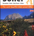
Mallorca’s central plain with the south-eastern and eastern coast on a waterproof and tear-resistant, double-sided, contoured and GPS compatible map at 1:50,000 from Editorial Alpina, highlighting hiking trails plus cycling and mountain biking routes, including 27 recommendations with English language descriptions in the accompanying booklet.The double-sided map has contours at 20m intervals with additional altitude colouring. Hiking and cycling routes are highlighted and mountain bike trails are graded according to three degrees of difficulty. Road network indicates picturesque routes and symbols show campsites, hotels or inns, tourist information offices, wine cellars, viewpoints, climbing sites, etc. The map has a 5km UTM grid. Two locations, the Randa area north of Llucmajor plus the hills south-east of Felanitx are also presented on more detailed enlargements. PLEASE NOTE: this title comes with only one map, double-sided to cover two areas of the island, hence the publishers’ somewhat confusing note on the booklet covers referring to two maps.A separate booklet provides general information and practical advice, plus divides the area covered by the map into three region, recommending in each one a selection of hiking trails, mountain biking locations and scenic routes along the roads. Map legend and all the text include English.To see other titles in Editorial Alpina’s coverage of Mallorca and the rest of Spain, please click on the series link.

Related Products:
 Mallorca North Walking & Cycling Map & Guide Editorial Alpina
 Caps del Nord – Mallorca Editorial Alpina 2-Map Set
 Mallorca – Tramuntana Central Editorial Alpina
 Mallorca – Tramuntana South Editorial Alpina
 Mallorca Editorial Alpina Cycling Map
 Mallorca – Tramuntana North Editorial Alpina
 Mallorca – 60 Easy Hikes Editorial Alpina GR211-GR222 ENGLISH/GERMAN
 Ibiza – Formentera Editorial Alpina
 Sรณller – Mallorca Editorial Alpina Map & Guide ENGLISH
 Serra de Tramuntana Editorial Alpina 4-Map Set
 Sobrarbe Central – Ainsa – Boltana Editorial Alpina
 Cabo de Gata-Nรญjar Natural Park Editorial Alpina
 Garrotxa – Zona Volcanica Editorial Alpina
 Menorca – Camรญ de Cavalls – GR223 Editorial Alpina CATALAN
 Taga – Serra Cavallera Editorial Alpina
 Sierra y Canones de Guara Editorial Alpina
 Ordesa and Monte Perdido National Park Editorial Alpina
 Serra del Cadรญ – Pedraforca Editorial Alpina
 Posets-Maladeta Natural Park 2-Map Set Editorial Alpina
Montnegre – Corredor Editorial Alpina
Posets-Maladeta Natural Park 2-Map Set Editorial Alpina
Montnegre – Corredor Editorial Alpina
 Ordesa – Monte Perdido National Park Editorial Alpina 2-Map Set
 Cap de Creus Park Natural Editorial Alpina
 Menorca – Camรญ de Cavalls – GR223 Editorial Alpina ENGLISH
Cingles de Berti – Sant Miquel des Fai Editorial Alpina
Menorca – Camรญ de Cavalls – GR223 Editorial Alpina ENGLISH
Cingles de Berti – Sant Miquel des Fai Editorial Alpina
 Ordesa and Monte Perdido National Park 2-Map Set Editorial Alpina
 Vall Fosca – Montsent de Pallars Editorial Alpina 2-Map Set
Puigsacalm – Bellmunt Editorial Alpina
Sierra Nevada – La Alpujarra Editorial Alpina
Vall Fosca – Montsent de Pallars Editorial Alpina 2-Map Set
Puigsacalm – Bellmunt Editorial Alpina
Sierra Nevada – La Alpujarra Editorial Alpina
 Macizo de Monte Perdido – Valle de Ordesa – Pineta Editorial Alpina
 Valle de Benasque Editorial Alpina
Valles de Ansรณ & Echo Editorial Alpina
Aigรผestortes and Estany de Sant Maurici National Park 2-Map Set Editorial Alpina
Valle de Benasque Editorial Alpina
Valles de Ansรณ & Echo Editorial Alpina
Aigรผestortes and Estany de Sant Maurici National Park 2-Map Set Editorial Alpina
 Collserola Parc Natural Editorial Alpina
Spain: Editorial Alpina Walking Maps
Collserola Parc Natural Editorial Alpina
Spain: Editorial Alpina Walking Maps
 Sierra de Gredos – Almanzor – Laguna Grande Editorial Alpina
Montseny NP – Turo de l`Home – Les Agudas – Matagalls – la Calma Editorial Alpina 2-Map Set
Sant Llorenc del Munt i l`Obac Editorial Alpina
Sierra de Gredos – Almanzor – Laguna Grande Editorial Alpina
Montseny NP – Turo de l`Home – Les Agudas – Matagalls – la Calma Editorial Alpina 2-Map Set
Sant Llorenc del Munt i l`Obac Editorial Alpina
 Catllarร s – Picancel Editorial Alpina
 Valles de Belagua y Roncal Editorial Alpina
 Cavalls del Vent – Cadi-Moixero Natural Park Hiking Circuit Editorial Alpina